Hinoemata, Fukushima: Difference between revisions
→Transportation: Added information about bus service to Hinoemata. |
Rescuing 1 sources and tagging 0 as dead. #IABot (v1.6) |
||
| Line 169: | Line 169: | ||
{{Commons category-inline}} |
{{Commons category-inline}} |
||
*{{Official website| http://www.hinoemata.com/oze/}} {{ja icon}} |
*{{Official website| http://www.hinoemata.com/oze/}} {{ja icon}} |
||
* [http://www.oze-fnd.or.jp/english/frmain_e.html The Oze Preservation Foundation English website] |
* [https://web.archive.org/web/20100530130512/http://www.oze-fnd.or.jp/english/frmain_e.html The Oze Preservation Foundation English website] |
||
{{Fukushima}} |
{{Fukushima}} |
||
Revision as of 05:59, 4 November 2017
This article needs additional citations for verification. (October 2014) |
Hinoemata
檜枝岐村 | |
|---|---|
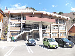
 Hinoemata Village Hall | |
 Location of Hinoemata in Fukushima Prefecture | |
| Coordinates: 37°1′27″N 139°23′21″E / 37.02417°N 139.38917°E | |
| Country | Japan |
| Region | Tōhoku |
| Prefecture | Fukushima Prefecture |
| District | Minamiaizu District |
| Area | |
| • Total | 390.50 km2 (150.77 sq mi) |
| Population (September 2014) | |
| • Total | 616 |
| • Density | 1.58/km2 (4.1/sq mi) |
| Time zone | UTC+9 (Japan Standard Time) |
| - Tree | Chamaecyparis obtusa |
| - Flower | Asian skunk cabbage |
| Phone number | 0241-75-2311 |
| Address | 880 Shimonohara, Hinoemata-mura, Minamiaizu-gun, Fukushima-ken 967-0525 |
| Website | Official HP |

Hinoemata (檜枝岐村, Hinoemata-mura) is a village located in Minamiaizu District, Fukushima Prefecture, in northern Honshū, Japan. As of September 2014, the village had an estimated population of 616 and a population density of 1.58 persons per km². The total area was 390.50 km². It is locally famous for its soba (buckwheat noodles) and known nationally for its kabuki performances and as a gateway to the Oze marshlands.
Geography
Located in the southwestern corner of Fukushima prefecture, Hinoemata is surrounded by the mountains Komagatake, Mount Taishaku, and Hiuchigatake (the highest mountain in northwestern Japan). Between these mountains runs the Hinoemata River. It is known for having the lowest population density of any municipality in Japan.
- Mountains: Aizu-Komagatake (2133 m), Mount Taishaku (2060 m), Hiuchigatake (2356 m)
- Rivers: Hinoemata River
- Lakes: Ozegahara
Neighboring municipalities
History
The area of present-day Hinoemata was part of ancient Mutsu Province and formed part of the holdings of Aizu Domain during the Edo period. After the Meiji Restoration, it was organized as part of Minamiaizu District.
Hinoemata was formed on April 1, 1889 with the establishment of the municipalities system.
Economy
The economy of Hinoemata is primarily agricultural.
Education
- Hinoemata Elementary School
- Hinoemata Intermediate School
Transportation
Railway
Hinoemata is not served by any train stations.
Highway
Bus
Hinoemata is served by a single local bus line connecting it with Aizukogenozeguchi and Aizu-Tajima stations in neighboring Minami-Aizu Town. [1]
Local attractions
- Okutadami Dam (Hinoemata is situated on the east bank of the dam lake.)
- Hinoemata Hot Spring
- Sanjō Falls
- Takeda Hisayoshi Memorial Hall
External links
![]() Media related to Hinoemata, Fukushima at Wikimedia Commons
Media related to Hinoemata, Fukushima at Wikimedia Commons


