
Wikipedia:Graphics Lab/Map workshop: Difference between revisions
Treetoes023 (talk | contribs) No edit summary |
→Request: new section |
||
| Line 301: | Line 301: | ||
;Discussion: |
;Discussion: |
||
:{{Ping|M.Bitton}} Could you do this request? As always, it's okay if you don't want to or can't, I know you are busy and you are under no obligation to do this request. – [[User:Treetoes023|Treetoes023]] ([[User talk:Treetoes023|talk]]) 22:17, 25 July 2023 (UTC) |
:{{Ping|M.Bitton}} Could you do this request? As always, it's okay if you don't want to or can't, I know you are busy and you are under no obligation to do this request. – [[User:Treetoes023|Treetoes023]] ([[User talk:Treetoes023|talk]]) 22:17, 25 July 2023 (UTC) |
||
== Request == |
|||
== Replace font in map == |
|||
<gallery> |
|||
First Sino-Japanese War.svg|Map in question |
|||
</gallery> |
|||
;Article(s): |
|||
: [[History of East Asia]] |
|||
: [[Korea under Japanese rule]] |
|||
: and many more |
|||
;Request: |
|||
: Simple font replacement. It's a great map, but the font feels like a [[Wonton font]]. The orig creator's other maps of East Asia (notably Japan) use similar fonts, but their maps for elsewhere do not. I think they had good intentions, but a more neutral font would raise fewer eyebrows. -- [[User:Toobigtokale|toobigtokale]] ([[User talk:Toobigtokale|talk]]) 00:35, 27 July 2023 (UTC) |
|||
;Discussion: |
|||
Revision as of 00:35, 27 July 2023
The Graphics Lab is a project to improve the graphical content of the Wikimedia projects. Requests for image improvements can be added to the workshop pages: Illustrations, Photographs and Maps. For questions or suggestions one can use the talk pages: Talk:Graphics Lab, Talk:Illustrations, Talk:Photographs and Talk:Maps.
This specific page is the requests page for the Map workshop. Anyone can make a request for a map to be created or improved for a Wikipedia article. The standard format for making a request is shown below, along with general advice, and should be followed.
You are encouraged to share information and request advice from others. Also see possible conventions toolbox, map tutorials and topographic map tutorials.
| Advice to requesters |
|---|
|
What do we do?
|


| If you have completed work and not received a reply you may use the {{GL Map reply}} template to inform the requester. |
| Map makers and other visitors to the Graphics Lab may be interested in the RSS feed of changes to this page. You may find it here. |
| See also our sister Map workshop at Commons and the WikiProject Maps |
| Result | Code | Usage |
|---|---|---|
{{resolved|~~~~}}
|
Mark a thread as resolved and request archiving | |
{{subst:bump}}
|
Delay automatic archiving of a section for 30 days | |
{{I take|~~~~}}
|
When you'll be working on the request | |
{{Done}} ~~~~
|
When the request is done |
This page is automatically archived by ClueBot III. | |
| This page has a backlog that requires the attention of willing editors. Please remove this notice when the backlog is cleared. |
US State Map
- Article(s)
- Transgender rights in the United States
- Transgender health care
- Request
- Hi I am just wondering can somebody make a US Map of US State and their law on Bans of medical transition for people under 18. Here are sources. They have maps for Bathroom bills, and Fairness in Women's Sports Act but none for state laws on bans on medical stuff. La lopi (talk) 08:11, 4 July 2023 (UTC)
Data & References
| |||||||||||||||||||||||||||||||||||||||||||||||||||||||||||||||||||||||||||||||||||||||
|---|---|---|---|---|---|---|---|---|---|---|---|---|---|---|---|---|---|---|---|---|---|---|---|---|---|---|---|---|---|---|---|---|---|---|---|---|---|---|---|---|---|---|---|---|---|---|---|---|---|---|---|---|---|---|---|---|---|---|---|---|---|---|---|---|---|---|---|---|---|---|---|---|---|---|---|---|---|---|---|---|---|---|---|---|---|---|---|
References
|
- Discussion
Swamps in Belarus in png
-
 original maps
 -
 can be used as base?


- Article(s)
- Swamps in Belarus (new article)
- Request
- I'd like to get a png map of swamps in Belarus. Please leave only the year under each map, and use English for city names. Thanks! Artem.G (talk) 05:49, 27 June 2023 (UTC)
- Discussion
Updates to map of country subdivisions
-
 Map of world subdivisions

- Article(s)
- Administrative division and others
- Request
- Could someone update the map of national subdivisions for the following changes?: new cantons in Luxembourg, municipalities in Latvia, new regions in Chile, Tanzania, the Philippines, Mali, Kazakhstan, Ghana, and Ethiopia, new prefectures in the Central African Republic, new provinces in Equatorial Guinea, Burundi, Algeria, Laos, Indonesia, Nepal, and the Democratic Republic of the Congo, new governorates in Lebanon, new administrative area in South Sudan have been created. -- HapHaxion (talk / contribs) 23:58, 3 July 2023 (UTC)
- Discussion
Bancroft, Ontario, Canada, map of geological locations
-
 Map uranium mines around Bancroft
 -
 Finished map


- Article(s)
- Uranium mining in the Bancroft area
- Request
- Could this map be redone please? Requesting addition of colour, hopefully allowing it to be used at a smaller size. (This is as requested by a reviewer while the article is being reviewed on the path to Featured Article status (link for more context) -- CT55555(talk) 12:04, 9 July 2023 (UTC)
- Discussion
 Bumping thread. I might be able to work on this but depends if I get the time. – Isochrone (T) 11:52, 22 July 2023 (UTC)
 Request taken. – Isochrone (T) 17:14, 23 July 2023 (UTC)
- @CT55555 hi @CT55555, so I've done your request but there are some stupid SVG bugs that are being really irksome, the file is here but it doesn't display correctly until you click on the thumbnail to load the SVG in your browser. I've asked for some help on the relevant forum and if it doesn't work I may just say the file as a PDF (hopefully not).In the meantime, feel free to suggest any changes as appropriate. I have intentionally neglected a key as it would make more sense in the caption. The relevant wikitext is below. I also made a shaded relief background, as I thought the geology was relevant, but I'm happy to remove it.Granite, granitic gneissParagneiss para-amphiboliteMarbleSyenite, syenitic and hybrid gneissMetagabbro– Isochrone (T) 20:34, 23 July 2023 (UTC)
- @CT55555,
 Done File:Bancroft uranium mining map.svg fixed and ready for use, feel free to suggest changes as appropriate. – Isochrone (T) 09:32, 24 July 2023 (UTC)
- @CT55555,
- @CT55555 hi @CT55555, so I've done your request but there are some stupid SVG bugs that are being really irksome, the file is here but it doesn't display correctly until you click on the thumbnail to load the SVG in your browser. I've asked for some help on the relevant forum and if it doesn't work I may just say the file as a PDF (hopefully not).In the meantime, feel free to suggest any changes as appropriate. I have intentionally neglected a key as it would make more sense in the caption. The relevant wikitext is below. I also made a shaded relief background, as I thought the geology was relevant, but I'm happy to remove it.
Tour de France Femmes 2023
-
 Finished map

- Article(s)
- 2023 Tour de France Femmes
- Request
- Hi, I'm looking for someone to do a free version of the 2023 Tour de France Femmes map - the official one is here. As with last year, I asked Andrei loas who has previously done excellent maps (e.g. this for the 2022 men's race) if he could create one, but he hasn't got back to me unfortunately.
This is last years map, by the excellent M.Bitton.

Turini2 (talk) 21:13, 10 July 2023 (UTC)
- Discussion
- Request taken by M.Bitton (talk) 12:44, 14 July 2023 (UTC).
- @Turini2: Done Please double-check everything and let me know if I missed something. M.Bitton (talk) 10:37, 23 July 2023 (UTC)
Singapore whiskered bat range map
- Article(s)
- Singapore whiskered bat
- Request
- Please create a range map based on the data described at the IUCN Redlist entry. -- UtherSRG (talk) 22:50, 10 July 2023 (UTC)
- Discussion
- Not sure if {{maplink}} works with speciesbox, but considering the small scale, it would be best for this. – Isochrone (T) 10:13, 24 July 2023 (UTC)
Locator map of the Balkans in the gray and green globe scheme
- Article(s)
- Balkans
- Request
- Create a locator map of the Balkans in the gray and green globe scheme. -- Treetoes023 (talk) 23:07, 10 July 2023 (UTC)
- Discussion
Maps displaying the Asian and European parts of Azerbaijan, Georgia, and Kazakhstan
-
 Example image showing the African and Asian parts of Egypt

- Article(s)
- List of transcontinental countries
- Request
- Make maps displaying the Asian and European parts of Azerbaijan, Georgia, and Kazakhstan in the same style as the example image showing the African and Asian parts of Egypt.
- Here is how the border between the Asian and European parts of each country is defined:
- Azerbaijan
- Asian part: Land south of the Greater Caucasus Watershed.
- European part: Land north of the Greater Caucasus Watershed.
- Georgia
- Asian part: Land south of the Greater Caucasus Watershed.
- European part: Land north of the Greater Caucasus Watershed.
- Kazakhstan
- Asian part: Land east of the Ural River.
- European part: Land west of the Ural River.
- -- Treetoes023 (talk) 23:32, 10 July 2023 (UTC)
- Discussion
Map displaying the North American and South American parts of Panama
-
Example image showing the African and Asian parts of Egypt
- Article(s)
- List of transcontinental countries
- Request
- Make a map displaying the North American and South American parts of Panama in the same style as the example image showing the African and Asian parts of Egypt. -- Treetoes023 (talk) 23:32, 10 July 2023 (UTC)
- Discussion
- @Treetoes023: there is no consensus as to what the boundary is between North and South America --Guerillero Parlez Moi 09:35, 22 July 2023 (UTC)
- @Guerillero: Isn't the Panama Canal the boundary between North America and South America, just like the Suez Canal is the boundary between Africa and Asia? – Treetoes023 (talk) 17:45, 22 July 2023 (UTC)
- Not always. Serranía del Darién is also a common choice for cartographers --Guerillero Parlez Moi 20:46, 22 July 2023 (UTC)
- @Guerillero: Oh, well in that case we should have a map that shows both borders, like this map does for the border(s) between Europe and Asia. – Treetoes023 (talk) 22:26, 22 July 2023 (UTC)
- Not always. Serranía del Darién is also a common choice for cartographers --Guerillero Parlez Moi 20:46, 22 July 2023 (UTC)
- @Guerillero: Isn't the Panama Canal the boundary between North America and South America, just like the Suez Canal is the boundary between Africa and Asia? – Treetoes023 (talk) 17:45, 22 July 2023 (UTC)
Gordie Howe International Bridge map
- Article(s)
- Gordie Howe International Bridge
- Request
- Hello, can someone extract the details of the Gordie Howe International Bridge from OpenStreetMap and make a map with labels? The bridge is located in Detroit, Michigan, United States and Windsor, Ontario, Canada. I made an example to show the relevant labelling, but it's not wikipedia worthy! Thanks! Turini2 (talk) 07:46, 25 July 2023 (UTC)
- Discussion
Indiana Jones locations map
(this request is also present in the Commons:Graphic Lab/Map workshop)

- Article(s)
- Indiana Jones
- Request
- Could someone please modify the above map showing the countries visited throughout the Indiana Jones film franchise, to include those in which on-screen events occur during The Dial of Destiny film. Having seen the film recently, I can confirm that the relevant countries are: France, the United States, the United Kingdom, Morocco, Greece and Italy.
- I'd recommend using the same shade of purple in which the United States is already shaded to represent the new set of countries. And I'd also recommend using a diagonal stripe pattern for countries seen in more than one film (similar to Peru). Which means the United States should be re-shaded in red-blue-yellow-purple stripes, and Italy should be re-shaded in blue and purple stripes. Thanks. Snow Lion Fenian (talk) 13:15, 25 July 2023 (UTC)
- Discussion
SVG locator map of European Russia in the gray and green globe scheme
-
 Map of the Ural Mountains.

- Article(s)
- European Russia
- Request
- Create an SVG locator map of European Russia in the gray and green globe scheme. The boundary between Europe and Asia is the Ural Mountains. -- Treetoes023 (talk) 22:13, 25 July 2023 (UTC)
- Discussion
- @M.Bitton: Could you do this request? As always, it's okay if you don't want to or can't, I know you are busy and you are under no obligation to do this request. – Treetoes023 (talk) 22:17, 25 July 2023 (UTC)
Request
Replace font in map
-
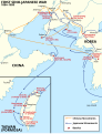 Map in question

- Article(s)
- History of East Asia
- Korea under Japanese rule
- and many more
- Request
- Simple font replacement. It's a great map, but the font feels like a Wonton font. The orig creator's other maps of East Asia (notably Japan) use similar fonts, but their maps for elsewhere do not. I think they had good intentions, but a more neutral font would raise fewer eyebrows. -- toobigtokale (talk) 00:35, 27 July 2023 (UTC)
- Discussion