Ise-Shima National Park
| Ise-Shima National Park | |
|---|---|
| 伊勢志摩国立公園 | |
 | |
| Location | Honshū, Japan |
| Nearest city | Ise, Mie |
| Coordinates | 34°27′18″N 136°43′33″E / 34.45500°N 136.72583°E |
| Area | 555.49 km2 (214.48 sq mi) |
| Established | November 20, 1946[1] |
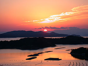
Ise-Shima National Park (伊勢志摩国立公園, Ise-Shima Kokuritsu Kōen) is a national park in Mie Prefecture, Japan. It is characterized by its ria coast and islands scattered around a number of bays. The interior is hilly with Mount Asama-ga-take (555 meters (1,821 ft) the highest peak.[2][3]
Natural areas
- Ago Bay
- Kami-shima
- Kashiko-jima
- Kozukumi-jima
- Gokasho Bay
- Matoya Bay
- Mount Asama-ga-take 555 meters (1,821 ft)
- Tōshi-jima
Cultural sites
Related municipalities
See also
References
- ^ "Ise-Shima National Park". Ministry of the Environment. Archived from the original on 22 March 2011. Retrieved 11 April 2011.
- ^ "Ise-Shima National Park". National Parks Foundation. Archived from the original on 11 June 2011. Retrieved 11 April 2011.
- ^ "Introducing places of interest: Ise-Shima National Park". Ministry of the Environment. Archived from the original on 22 March 2011. Retrieved 11 April 2011.
- ^ "Basic information". Ministry of the Environment. Archived from the original on 22 September 2012. Retrieved 11 April 2011.
- ^ "Ise-Shima National Park". Mie Prefecture. Retrieved 3 February 2012.[permanent dead link]
External links
Wikimedia Commons has media related to Ise-Shima National park.
- (in Japanese) Ise-Shima National Park
- (in English) Ise-Shima National Park
- (in Japanese) Map of Ise-Shima National Park (PDF)

