
Portal:Myanmar
ကြိုဆိုပါတယ်။ / Welcome to the Myanmar Portal 

Myanmar, officially the Republic of the Union of Myanmar and also known as Burma (the official name until 1989), is a country in Southeast Asia. It is the largest country by area in Mainland Southeast Asia and has a population of about 55 million. It is bordered by Bangladesh and India to its northwest, China to its northeast, Laos and Thailand to its east and southeast, and the Andaman Sea and the Bay of Bengal to its south and southwest. The country's capital city is Naypyidaw, and its largest city is Yangon (formerly Rangoon).
Myanmar is a member of the East Asia Summit, Non-Aligned Movement, ASEAN, and BIMSTEC, but it is not a member of the Commonwealth of Nations despite once being part of the British Empire. Myanmar is a Dialogue Partner of the Shanghai Cooperation Organization. The country is very rich in natural resources, such as jade, gems, oil, natural gas, teak and other minerals, as well as also endowed with renewable energy, having the highest solar power potential compared to other countries of the Great Mekong Subregion. However, Myanmar has long suffered from instability, factional violence, corruption, poor infrastructure, as well as a long history of colonial exploitation with little regard to human development. In 2013, its GDP (nominal) stood at US$56.7 billion and its GDP (PPP) at US$221.5 billion. The income gap in Myanmar is among the widest in the world, as a large proportion of the economy is controlled by cronies of the military junta. Myanmar is one of the least developed countries; as of 2020, according to the Human Development Index, it ranks 147 out of 189 countries in terms of human development, the lowest in Southeast Asia. Since 2021, more than 600,000 people were displaced across Myanmar due to the surge in violence post-coup, with more than 3 million people in dire need of humanitarian assistance. (Full article...)
Selected articles -
-

The 1968 Burma cyclone was regarded as the worst to strike the country during the 20th century before it was surpassed by another unnamed cyclone in 2004 and further, Cyclone Nargis in 2008, respectively. The first tropical cyclone of the 1968 North Indian Ocean cyclone season, it started as a depression on May 7 on the northern Andaman Sea. With low wind shear and warm sea surface temperatures, the storm intensified in the waters near Burma before heading northwestwards. It then started to rapidly intensify, with an eye becoming apparent on satellite imagery on May 9. Also that day, it reached its peak intensity, with 3-minute maximum sustained winds of 220 km/h (140 mph) by the Indian Meteorological Department, which is equivalent to a super cyclonic storm; however, the agency treated the system as a severe cyclonic storm. Little to no changes happened on the cyclone as it turned northeastwards, making landfall near Akyab (now Sittwe) between 18:00 and 21:00 UTC on that day. Land interaction rapidly weakened the storm, dissipating on May 10 as an area of low-pressure in south Chin State.
The predecessor to the cyclone caused light to moderate downpour to the Andaman Islands; however, no deaths were reported. Winds reported from the cyclone inland Burma reached an estimate of 60–100 mph, altogether with heavy rainfall and large storm surges. The former flooded the crops, submerging them in floodwaters in the process while the latter washed out villages near the path of the storm. Schools and hospitals throughout Akyab were destroyed by high winds and large waves, while the port suffered major damages. The town was almost destroyed due to the storm. In addition, some ships in the said harbor, including the Greek freighter Geros Michalos were reportedly sunk in the Bay of Bengal. Houses were destroyed during the storm and many livestock died, mainly due to drowning. The death toll from the cyclone was finalized in May 1968 at 1,037 individuals, while 2,000 more were reportedly missing. The property damages were estimated at Ks.15 million ($3.248 million USD). (Full article...) -
Maung Thura "Zarganar" (also called Zaganar, Burmese: ဇာဂနာ; also Zargana, pronounced [zàɡənà]); born 27 January 1961) is a popular Burmese comedian, film actor, and a film director as well as a fierce critic and often political prisoner of the Burmese military government. Known for his wicked puns against the government which is a military junta, Zarganar, whose name translates to "tweezers", is widely considered to be the most popular comedian and satirist in Myanmar.
In September 2006, Zarganar was banned indefinitely from performing publicly or participating in any kind of entertainment related work. He was arrested on 4 June 2008 for speaking to foreign media about the situation of millions of people left homeless after a cyclone devastated the Irrawaddy Delta. In November 2008, he was sentenced to 59 years in prison, convicted of "public order offenses", under four sections of the criminal code—17/2, 32 (b), 295 (a) and 505 (b), much more than the anticipated maximum of two years. On 16 February 2009, following the appeals by the family, Yangon Divisional Court reduced the prison sentence by "up to 24 years", bringing the sentence down to 35 years. In December 2008, Zarganar has been sent to Myitkyina Prison in Kachin State in the country's far north, from which he was freed on 11 October 2011 in a mass amnesty of political prisoners. (Full article...) -
Mandalay International Airport (IATA: MDL, ICAO: VYMD), located 35 km south of Mandalay in Tada-U, is one of three international airports in Myanmar. Completed in 1999, it replaced the old Mandalay Chanmyathazi Airport as the city's main airport and it was the largest and most modern airport in the country until the modernization of Yangon International Airport in 2008. The airport connects 11 domestic and seven international destinations. Its 4,267 m (13,999 ft) runway is the longest runway in use in Southeast Asia and has the capacity to handle up to 3 million passengers a year. (Full article...) -

Myitkyina (Burmese: မြစ်ကြီးနားမြို့; MLCTS: mrac kri: na: mrui., pronounced [mjɪʔtɕíná]; (Eng; mitchinar) Jinghpaw: Myitkyina, [mjìtkjí̠ná]) is the capital city of Kachin State in Myanmar (Burma), located 1,480 kilometers (920 mi) from Yangon, and 785 kilometers (488 mi) from Mandalay. In Burmese it means "near the big river", and Myitkyina is on the west bank of the Ayeyarwady River, just below 40 kilometers (25 mi) from Myit-son (Burmese for confluence) of its two headstreams (the Mali and N'mai rivers). It is the northernmost river port and railway terminus in Myanmar. The city is served by Myitkyina Airport. (Full article...) -
The Burmese calendar (Burmese: မြန်မာသက္ကရာဇ်, pronounced [mjəmà θɛʔkəɹɪʔ], or ကောဇာသက္ကရာဇ်, [kɔ́zà θɛʔkəɹɪʔ]; Burmese Era (BE) or Myanmar Era (ME)) is a lunisolar calendar in which the months are based on lunar months and years are based on sidereal years. The calendar is largely based on an older version of the Hindu calendar, though unlike the Indian systems, it employs a version of the Metonic cycle. The calendar therefore has to reconcile the sidereal years of the Hindu calendar with the Metonic cycle's near tropical years by adding intercalary months and days at irregular intervals.
The calendar has been used continuously in various Burmese states since its purported launch in 640 CE in the Sri Ksetra Kingdom, also called the Pyu era. It was also used as the official calendar in other mainland Southeast Asian kingdoms of Arakan, Lan Na, Xishuangbanna, Lan Xang, Siam, and Cambodia down to the late 19th century. (Full article...) -
General elections were held in Myanmar on 8 November 2015, with the National League for Democracy winning a supermajority of seats in the combined national parliament. Voting occurred in all constituencies, excluding seats appointed by the military, to select Members of Assembly to seats in both the upper house (the House of Nationalities) and the lower house (the House of Representatives) of the Assembly of the Union, and State and Region Hluttaws. Ethnic Affairs Ministers were also elected by their designated electorates on the same day, although only select ethnic minorities in particular states and regions were entitled to vote for them.
These polls were the first openly contested election held in the country since 1990, which was annulled by the military government after the National League for Democracy's (NLD) victory. The poll was preceded by the 2010 general election, which was marred by a boycott and widespread allegations of systematic fraud by the victorious Union Solidarity and Development Party (USDP). (Full article...) -
Myint Myint Khin FRCP (Burmese: မြင့်မြင့်ခင်, pronounced [mjɪ̰ɰ̃ mjɪ̰ɰ̃ kʰɪ̀ɰ̃]; 15 December 1923 – 19 June 2014) was a Burmese medical professor and writer. An English major at the University of Rangoon, she was the chair of the Department of Medicine of the Institute of Medicine, Mandalay from 1965 to 1984, and served as a consultant at the World Health Organization from 1985 to 1991. Her literary career began in 1996, spurred on by the HIV/AIDS crisis in the country. She published 11 books in Burmese and two in English. At the time of her death, the former professor was collaborating on an English language book on the history of medical education in the country.
Most of her books dealt with public health and medicine. One notable exception was her last published book in 2013, Poetry for Me, a collection of her English language poetry, which she began working on after the death of her husband Dr. San Baw, a hip replacement pioneer, in 1984. Through her books and interviews, she advocated for more openness and transparency in the country, and spoke out about the regression of women's rights in Myanmar. In 2012, she founded a daycare center for elderly physicians in Yangon. (Full article...) -

Bawbawgyi Pagoda is one of the earliest existing examples of a Burmese pagoda.
Burmese pagodas are stupas that typically house Buddhist relics, including relics associated with Buddha. Pagodas feature prominently in Myanmar's landscape, earning the country the moniker "land of pagodas." According to 2016 statistics compiled by the State Sangha Maha Nayaka Committee, Myanmar is home to 1,479 pagodas exceeding 27 feet (8.2 m) in height, a quarter of which are located in Sagaing Region. Several cities in the country, including Mandalay and Bagan, are known for their abundance of pagodas. Pagodas are the site of seasonal pagoda festivals.
Burmese pagodas are enclosed in a compound known as the aran (အာရာမ်, from Pali ārāma), with gateways called mok (မုခ်, from Pali mukha) at the four cardinal directions. The platform surrounding a Burmese pagoda is called a yinbyin (ရင်ပြင်). (Full article...) -
Thado Dhamma Yaza III (Burmese: သတိုးဓမ္မရာဇာ, pronounced [ðədó dəma̰ jàzà]; also known as Mingyi Hnaung (မင်းကြီးနှောင်း, [mɪ́ɴdʑí n̥áʊɴ]); c. 1571–1597) was viceroy of Prome (Pyay) from 1589 to 1595, and self-styled king of Prome from 1595 to 1597. Hnaung was initially a loyal vassal of his father King Nanda until 1594 when he openly clashed with his brother Crown Prince Minye Kyawswa. Hnaung revolted in 1595 during the Siamese siege of Pegu (Bago). His revolt started a string of other revolts by the major vassal states of the Toungoo Empire in the next two years. His attempts to take over territories beyond Prome's traditional vassals in the present-day Magwe Region were unsuccessful. The self-proclaimed king was assassinated by Yan Naing, one of his trusted advisers, on the eve of his planned invasion of Upper Burma in 1597. (Full article...)
-

Burma (Myanmar) was under the military dictatorship of Ne Win from 1962 to 1988. Ne Win and his allies in the Tatmadaw (Burmese military) overthrew the government of Prime Minister U Nu in a coup d'état on 2 March 1962. A day later, the coupists established the Revolutionary Council of the Union of Burma as the country's governing body. In April 1962, the Revolutionary Council introduced the Burmese Way to Socialism and declared it Burma's state ideology. The Revolutionary Council then founded the Burma Socialist Programme Party (BSPP) as the country's vanguard party on 4 July 1962. In 1974, Ne Win introduced a new constitution and replaced the Revolutionary Council with the People's Assembly, which consisted solely of BSPP members. The country's official name was also changed from the Union of Burma to the Socialist Republic of the Union of Burma.
Ne Win's governance of Burma was characterised by totalitarianism, isolationism, superstition, xenophobia, and a rejection of Cold War politics. Ne Win ruled Burma as a dictator, serving as both Chairman of the Revolutionary Council (later President of Burma) and Prime Minister of Burma, the country's head of state and the head of government, respectively. The nationalisation of major industries and rejection of foreign investment led to catastrophic declines in economic growth and living standards. (Full article...)


_-_panoramio_(1).jpg)


.svg)
Did you know (auto-generated) -

- ... that the talabaw soup, which consists primarily of bamboo shoots, is the essential dish of Myanmar's Karen people, who use it to supplement rice?
- ... that Rolling Stone named Mission of Burma's "Academy Fight Song" as one of the 100 greatest debut singles of all time?
- ... that the Burmese and South Korean first ladies held their first informal conversation 44 years after the establishment of bilateral relations between the two countries?
- ... that Thinzar Shunlei Yi hid in the Burmese jungle for a month and joined a rebel militia following the 2021 Myanmar coup d'état?
- ... that Esther Ze Naw, who appeared on the 2021 Time 100, was one of the few people in Myanmar who protested against Aung San Suu Kyi's defence of the military at the International Court of Justice in December 2019?
- ... that Maw Htun Aung, a Shan Nationalities League for Democracy candidate in the 2020 Myanmar general election, is Kachin, not Shan?
- ... that the Myanmar Coast Guard was initially proposed as a civilian law enforcement agency before being established as a branch of the military three years later?
- ... that while defending Zaw Myint Maung following his arrest by the Myanmar junta, lawyer Ywet Nu Aung was herself arrested and charged?
Related portals and projects
General images -
-
 The paddle steamer Ramapoora (right) of the British India Steam Navigation Company on the Rangoon river having just arrived from Moulmein. 1895. Photographers: Watts and Skeen (from History of Myanmar)
 -
 Myanmar (Burma) map of Köppen climate classification (from Geography of Myanmar)
 -
 Myinhkin thabin - equestrian sport (from Culture of Myanmar)
 -
 Protesters in Yangon with a banner that reads non-violence: national movement in Burmese, in the background is Shwedagon Pagoda. (from History of Myanmar)
 -

-
 British soldiers remove their shoes at the entrance of Shwedagon Pagoda. To the left, a sign reads "Foot wearing is strictly prohibited" in Burmese, English, Tamil, and Urdu. (from Culture of Myanmar)
 -

-
 Aerial view of a burned Rohingya village in Rakhine state, Myanmar, September 2017 (from History of Myanmar)
 -
 Former US President Barack Obama poses barefoot on the grounds of Shwedagon Pagoda, one of Myanmar's major Buddhist pilgrimage sites. (from Culture of Myanmar)
 -
 Pagan Kingdom during Narapatisithu's reign. Burmese chronicles also claim Kengtung and Chiang Mai. Core areas shown in darker yellow. Peripheral areas in light yellow. Pagan incorporated key ports of Lower Burma into its core administration by the 13th century. (from History of Myanmar)
 -
 Salween river at Mae Sam Laep on the Thai-Myanmar border (from Geography of Myanmar)
 -

-
 Grandfather Island, Dawei (from Geography of Myanmar)
 -
 British soldiers dismantling cannons belonging to King Thibaw's forces, Third Anglo-Burmese War, Ava, 27 November 1885. Photographer: Hooper, Willoughby Wallace (1837–1912). (from History of Myanmar)
 -
 A wide range of Burmese lacquerware from Bagan (from Culture of Myanmar)
 -
 A wedding procession, with the groom and bride dressed in traditional Burmese wedding clothes, reminiscent of royal attire (from Culture of Myanmar)
 -
 A large fracture on the Mingun Pahtodawgyi caused by the 1839 Ava earthquake. (from Geography of Myanmar)
 -
 Two female musicians play the saung at a performance in Mandalay. (from Culture of Myanmar)
 -
 Boxing match, 19th-century watercolour (from Culture of Myanmar)
 -
 Mountains near Pindaya on the Shan Plateau (from Geography of Myanmar)
 -
 Hlei pyaingbwè - a Burmese regatta (from Culture of Myanmar)
 -
 Sculpture of Myanmar mythical lion (from Culture of Myanmar)
 -
 Jade Mine in Hpakant (from Geography of Myanmar)
 -
 The shores of Irrawaddy River at Nyaung-U, Bagan (from Geography of Myanmar)
 -
 A group of Buddhist worshipers at Shwedagon Pagoda, an important religious site for Burmese Buddhists (from Culture of Myanmar)
 -
 Vegetable stall on the roadside at the Madras Lancer Lines, Mandalay, January 1886. Photographer: Hooper, Willoughby Wallace (1837–1912). (from History of Myanmar)
 -
 A bull fight, 19th-century watercolour (from Culture of Myanmar)
 -
 British soldiers on patrol in the ruins of the Burmese town of Bahe during the advance on Mandalay, January 1945. (from History of Myanmar)
 -
 Mount Popa, a dormant volcano in the Central Lowlands (from Geography of Myanmar)
 -

-
 Saint Mary's Cathedral in Downtown Yangon is the largest Roman Catholic cathedral in Burma. (from Culture of Myanmar)
 -
 Temples at Mrauk U, was the capital of the Mrauk U Kingdom, which ruled over what is now Rakhine State. (from History of Myanmar)
 -
 19th-century funeral cart and spire, which would form part of the procession from the home to the place of cremation (from Culture of Myanmar)
 -
 Political Map of Burma (Myanmar) c. 1450 CE. (from History of Myanmar)
 -
 The restored Taungoo or Nyaungyan dynasty c. 1650 CE. (from History of Myanmar)
 -
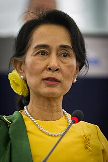
 Aung San Suu Kyi addresses crowds at the NLD headquarters shortly after her release. (from History of Myanmar)
 -
 A theatrical performance of the Mon dance (from Culture of Myanmar)
 -
 Protesters in Yangon carrying signs reading "Free Daw Aung San Suu Kyi" on 8 February 2021. (from History of Myanmar)
 -
 Recorder's Court on Sule Pagoda Road, with the Sule Pagoda at the far end, Rangoon, 1868. Photographer: J. Jackson. (from History of Myanmar)
 -
 Portuguese ruler and soldiers mounting an Elephant. Philips, Jan Caspar (draughtsman and engraver) (from History of Myanmar)


_headquarter.jpg)


Major topics
Categories

More topics

Associated Wikimedia
The following Wikimedia Foundation sister projects provide more on this subject:
-
 Commons
Free media repository -
 Wikibooks
Free textbooks and manuals -
 Wikidata
Free knowledge base -
 Wikinews
Free-content news -
 Wikiquote
Collection of quotations -
 Wikisource
Free-content library -
 Wikiversity
Free learning tools -
 Wikivoyage
Free travel guide -
 Wiktionary
Dictionary and thesaurus


