Goryōkaku: Difference between revisions
Removed duplicate and clean-up infobox. |
added Category:19th-century fortifications using HotCat |
||
| Line 58: | Line 58: | ||
[[Category:Coastal fortifications]] |
[[Category:Coastal fortifications]] |
||
[[Category:Star forts]] |
[[Category:Star forts]] |
||
[[Category:19th-century fortifications]] |
|||
Revision as of 04:48, 29 May 2018
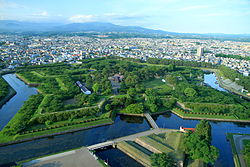
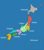
Goryōkaku (五稜郭) is a star fort in the Japanese city of Hakodate on the island of Hokkaido.[1][2] It was the main fortress of the short-lived Republic of Ezo.
History
Goryōkaku was designed in 1855 by Takeda Ayasaburō. His plan was based on the work of the French architect Vauban.[1] It is shaped like a five-pointed star. This allowed for greater numbers of gun emplacements on its walls than a traditional Japanese fortress, and reduced the number of blind spots where a cannon could not fire.
The fort was built by the Tokugawa shogunate to protect the Tsugaru Strait against a possible invasion by the Russian fleet.[1]
Goryōkaku is famous as the site of the last battle of the Boshin War. The fighting lasted for a week (June 20–27, 1869).[1]
Park
Today, Goryōkaku is a park. It has been declared a Special Historical Site and is home to the Hakodate city museum. The grounds are a favorite spot for cherry-blossom viewing in spring.
See also
- List of Special Places of Scenic Beauty, Special Historic Sites and Special Natural Monuments
- Benten Daiba, another key fortress of the Republic of Ezo
- Citadel Hill, a similar shaped fortress in Nova Scotia, Canada
References
- ^ a b c d Nussbaum, Louis-Frédéric (2002). Goryōkaku. Translated by Kathe Roth. London, England: Harvard University Press. p. 259. ISBN 0-674-00770-0.
{{cite book}}:|work=ignored (help) - ^ Hinago, Motoo (1986). Japanese Castles. Kodansha International Ltd. and Shibundo. p. 131-133. ISBN 0870117661.
Further reading
- Schmorleitz, Morton S. (1974). Castles in Japan. Tokyo: Charles E. Tuttle Co. p. 144. ISBN 0-8048-1102-4.


