
Miyazaki (city): Difference between revisions
m clean up, typo(s) fixed: km² → km<sup>2</sup> (2) |
m Fixed typo (via WP:JWB) |
||
| (44 intermediate revisions by 26 users not shown) | |||
| Line 1: | Line 1: | ||
{{Infobox settlement |
{{Infobox settlement |
||
| name = |
| name = Miyazaki |
||
| official_name = |
| official_name = |
||
| native_name = |
| native_name = {{nobold|宮崎市}} |
||
| native_name_lang = ja |
| native_name_lang = ja |
||
| settlement_type = [[Core cities of Japan|Core city]] |
| settlement_type = [[Core cities of Japan|Core city]] |
||
| other_name = |
| other_name = <!-- images, nickname, motto --> |
||
| image_skyline = Miyazaki Montage.jpg |
|||
<!-- images, nickname, motto --> |
|||
| imagesize = |
|||
| image_skyline = Route220 TachibanaStreet.jpg |
|||
| image_caption = <table style="width:280px;margin:2px auto; border-collapse: collapse"> |
|||
| imagesize = |
|||
<tr><td colspan="2">[[Aoshima, Miyazaki|Aoshima Island ]]</tr> |
|||
| image_caption = Tachibana Street in Miyazaki |
|||
<tr><td rowspan="2" style="vertical-align:middle">Sea Gaia resort<td>Tachibana Park Street</tr> |
|||
| image_flag = Flag of Miyazaki, Miyazaki.svg |
|||
<tr><td>[[Miyazaki Jingū]]</tr> |
|||
| image_seal = Emblem of Miyazaki, Miyazaki.svg |
|||
<tr><td colspan="2">[[Heiwadai Park]]</tr></table> |
|||
| seal_type = Emblem |
|||
| image_flag = Flag of Miyazaki, Miyazaki.svg |
|||
| image_seal = Emblem of Miyazaki, Miyazaki.svg |
|||
| seal_type = Emblem |
|||
<!-- maps and coordinates --> |
<!-- maps and coordinates --> |
||
| image_map = {{maplink|frame=yes|plain=yes|type=shape|stroke-width=2|stroke-color=#000000|zoom=8}} |
| image_map = {{maplink|frame=yes|plain=yes|type=shape|stroke-width=2|stroke-color=#000000|zoom=8}} |
||
| map_alt = |
| map_alt = |
||
| map_caption = Location of Miyazaki in |
| map_caption = Location of Miyazaki in Miyazaki Prefecture |
||
|image_map1 = Miyazaki in Miyazaki Prefecture Ja.svg |
| image_map1 = Miyazaki in Miyazaki Prefecture Ja.svg |
||
| map_caption1 = |
| map_caption1 = |
||
| pushpin_map = Japan |
| pushpin_map = Japan |
||
| pushpin_relief = |
| pushpin_relief = |
||
| pushpin_map_caption = Location in Japan |
| pushpin_map_caption = Location in Japan |
||
| coordinates = {{coord|31| |
| coordinates = {{coord|31|54|28|N|131|25|13|E|region:JP-45|display=it}} |
||
| coordinates_footnotes = <!-- for references: use <ref> tags --> |
| coordinates_footnotes = <!-- for references: use <ref> tags --> |
||
<!-- location --> |
<!-- location -->| subdivision_type = Country |
||
| subdivision_name = Japan |
|||
| subdivision_type = Country |
|||
| subdivision_type1 = [[List of regions of Japan|Region]] |
|||
| subdivision_name = Japan |
|||
| subdivision_name1 = [[Kyushu]] |
|||
| subdivision_type1 = [[List of regions of Japan|Region]] |
|||
| subdivision_type2 = [[Prefectures of Japan|Prefecture]] |
|||
| subdivision_name1 = [[Kyushu]] |
|||
| |
| subdivision_name2 = [[Miyazaki Prefecture|Miyazaki]] |
||
| subdivision_type3 = [[Districts of Japan|District]] |
|||
| subdivision_name2 = [[Miyazaki Prefecture]] |
|||
| subdivision_name3 = <!-- established --> |
|||
| subdivision_type3 = [[Districts of Japan|District]] |
|||
| established_title = <!-- Settled --> |
|||
| subdivision_name3 = |
|||
| established_date = |
|||
<!-- established --> |
|||
| extinct_title = Now part of |
|||
| established_title = <!-- Settled --> |
|||
| |
| extinct_date = |
||
| founder = |
|||
| extinct_title = Now part of |
|||
| named_for = <!-- seat, smaller parts --> |
|||
| extinct_date = |
|||
| seat_type = <!-- defaults to: Seat --> |
|||
| founder = |
|||
| seat = <!-- government type, leaders --> |
|||
| named_for = |
|||
<!-- seat, smaller parts --> |
|||
| seat_type = <!-- defaults to: Seat --> |
|||
| seat = |
|||
<!-- government type, leaders --> |
|||
| government_footnotes = <!-- for references: use <ref> tags --> |
| government_footnotes = <!-- for references: use <ref> tags --> |
||
| leader_party = |
| leader_party = |
||
| leader_title = Mayor |
| leader_title = Mayor |
||
| leader_name = |
| leader_name = Tomonori Kiyoyama |
||
| leader_title1 = Vice Mayor |
| leader_title1 = Vice Mayor |
||
| leader_name1 = |
| leader_name1 = <!-- display settings --> |
||
| total_type = <!-- to set a non-standard label for total area and population rows --> |
|||
<!-- display settings --> |
|||
| unit_pref = Metric |
|||
| total_type = <!-- to set a non-standard label for total area and population rows --> |
|||
<!-- area -->| area_magnitude = <!-- use only to set a special wikilink --> |
|||
| unit_pref = Metric |
|||
| area_footnotes = <!-- for references: use <ref> tags --> |
|||
<!-- area --> |
|||
| area_total_km2 = 643.67 |
|||
| area_magnitude = <!-- use only to set a special wikilink --> |
|||
| area_land_km2 = |
|||
| area_footnotes = <!-- for references: use <ref> tags --> |
|||
| area_water_km2 = |
|||
| area_total_km2 = 643.67 |
|||
| area_land_km2 = |
|||
| area_water_km2 = |
|||
| area_water_percent = |
| area_water_percent = |
||
| area_note = |
| area_note = <!-- elevation --> |
||
<!-- elevation --> |
|||
| elevation_footnotes = <!-- for references: use <ref> tags --> |
| elevation_footnotes = <!-- for references: use <ref> tags --> |
||
| elevation_m = |
| elevation_m = <!-- population --> |
||
| population_footnotes = <!-- for references: use <ref> tags --> |
|||
<!-- population --> |
|||
| population_total = 397,381 |
|||
| population_footnotes = <!-- for references: use <ref> tags --> |
|||
| population_as_of = September 1, 2023 |
|||
| population_total = 398215 |
|||
| population_as_of = June 1, 2019 |
|||
| population_density_km2 = auto |
| population_density_km2 = auto |
||
| population_est = |
| population_est = |
||
| pop_est_as_of = |
| pop_est_as_of = <!-- time zone(s) --> |
||
| timezone1 = [[Japan Standard Time|JST]] |
|||
<!-- time zone(s) --> |
|||
| utc_offset1 = +09:00 |
|||
| timezone1 = [[Japan Standard Time|JST]] |
|||
<!-- postal codes, area code -->| postal_code_type = |
|||
| utc_offset1 = +09:00 |
|||
| postal_code = |
|||
<!-- postal codes, area code --> |
|||
| area_code_type = <!-- defaults to: Area code(s) --> |
|||
| postal_code_type = |
|||
| area_code = <!-- blank fields (section 1) --> |
|||
| postal_code = |
|||
| blank_name_sec1 = City hall address |
|||
| area_code_type = <!-- defaults to: Area code(s) --> |
|||
| blank_info_sec1 = 1-1-1 Tachibana-dōri Nishi, Miyazaki-shi, Miyazaki-ken 880-8505 |
|||
| area_code = |
|||
<!-- blank fields (section |
<!-- blank fields (section 2) --> |
||
| blank_name_sec2 = [[Köppen climate classification|Climate]] |
|||
| blank_name_sec1 = City hall address |
|||
| blank_info_sec2 = [[Humid subtropical climate|Cfa]] |
|||
| blank_info_sec1 = 1-1-1 Tachibana-dōri Nishi, Miyazaki-shi, Miyazaki-ken<br />880-8505 |
|||
<!-- website, footnotes --> |
<!-- website, footnotes --> |
||
| website = {{ |
| website = {{Official|1=www.city.miyazaki.miyazaki.jp}} |
||
| footnotes = |
| footnotes = |
||
| module = {{Infobox place symbols| embedded=yes |
| module = {{Infobox place symbols| embedded=yes |
||
| tree = [[Cinnamomum camphora]] |
| tree = [[Cinnamomum camphora]] |
||
| flower = [[Iris ensata]], [[Camellia]] |
| flower = [[Iris ensata]], [[Camellia]] |
||
| Line 96: | Line 91: | ||
}} |
}} |
||
{{Infobox Chinese |
{{Infobox Chinese |
||
|pic= |
| pic = |
||
|piccap= |
| piccap = |
||
|picupright= |
| picupright = |
||
|kanji=宮崎 |
| kanji = 宮崎 |
||
|hiragana=みやざき |
| hiragana = みやざき |
||
|katakana=ミヤザキ |
| katakana = ミヤザキ |
||
|romaji=Miyazaki |
| romaji = Miyazaki |
||
}} |
}} |
||
{{nihongo|'''Miyazaki'''|宮崎市|Miyazaki-shi|extra={{IPA-ja|mijaꜜzaki|lang}}}} is the capital [[Cities of Japan|city]] of [[Miyazaki Prefecture]] on the island of [[Kyushu]] in Japan. |
{{nihongo|'''Miyazaki'''|宮崎市|Miyazaki-shi|extra={{IPA-ja|mijaꜜzaki|lang}}}} is the capital [[Cities of Japan|city]] of [[Miyazaki Prefecture]] on the island of [[Kyushu]] in Japan. {{As of|2023|09|01}}, the city had an estimated [[population]] of 397,381 in 187859 households, and a [[population density]] of 620 persons per km<sup>2</sup>. <ref name="Miyazaki-hp">{{cite web |url=https://www.city.miyazaki.miyazaki.jpl|title= Miyazaki City official statistics|location= Japan|language= ja}}</ref> The total area of the city is {{cvt|643.67|km2}}. |
||
==Geography== |
|||
[[Miyazaki Airport]] and Miyazaki seaport serve<ref>{{Cite web |url=http://www.miyazakicarferry.com/11_english/02_route/index.html |title=Miyazaki Car Ferry Routes and Timetables |access-date=2014-11-13 |archive-url=https://web.archive.org/web/20141113054356/http://www.miyazakicarferry.com/11_english/02_route/index.html |archive-date=2014-11-13 |url-status=dead }}</ref> the city. |
|||
Miyazaki is located at the southern end of the Miyazaki Plain, with the [[Ōyodo River]] flowing through the center and bordered by the [[Hyūga Sea]] to the east. Except for the southern part, which is part of the Wanizuka Mountains, most of the area of the city consists of flat [[alluvial plain]]s. |
|||
=== Surrounding municipalities === |
|||
==History== |
|||
In 1870, Hyuga Province was renamed to Miyazaki Prefecture with Miyazaki being its capital. After the completion of the nationwide railroad system, many new people began to settle in the area.<ref name=":0">{{Cite book|title=International Dictionary of Historic Places, Volume 5: Asia and Oceania|publisher=Fitzroy Dearborn Publishers|year=1996|isbn=1-884964-04-4|editor-last=Schellinger|editor-first=Paul|location=Chicago|pages=592–594|editor-last2=Salkin|editor-first2=Robert}}</ref> |
|||
In 1940, the imperialist Shōwa regime constructed the 37 meter [[Hakkō Ichiu]] pillar upon the legendary site of [[Emperor Jimmu]]'s palace. Located near Miyazaki, it was originally intended to symbolize the [[Hakko Ichiu|divine right of the Empire of Japan to "unify the eight corners of the world"]]. The tower survived the war and is now the center piece of the Heiwadai-koen peace park.<ref>[http://4travel.jp/traveler/godzilla/album/10230307/ Travelogue of Hakko Ichiu] at {{coord|31.9483|131.41457|type:landmark}}</ref> |
|||
On January 1, 2006, the towns of [[Sadowara, Miyazaki|Sadowara]] and [[Tano, Miyazaki|Tano]] (both from [[Miyazaki District, Miyazaki|Miyazaki District]]), and the town of [[Takaoka, Miyazaki|Takaoka]] (from [[Higashimorokata District, Miyazaki|Higashimorokata District]]) were merged into Miyazaki. |
|||
On March 23, 2010, the town of [[Kiyotake, Miyazaki|Kiyotake]] (from [[Miyazaki District, Miyazaki|Miyazaki District]]) was merged into Miyazaki. Miyazaki District was dissolved as a result of this merger.<ref name="Plannedmerge">{{cite web |url=http://www.kokudo.or.jp/new/cities/sub/kyusyu/45.htm |title=Archived copy |access-date=2008-09-13 |url-status=dead |archive-url=https://web.archive.org/web/20070629153802/http://www.kokudo.or.jp/new/cities/sub/kyusyu/45.htm |archive-date=2007-06-29 }}</ref> |
|||
== Surronding municipalities == |
|||
Miyazaki Prefecture |
Miyazaki Prefecture |
||
* [[Miyakonojō]] |
* [[Miyakonojō]] |
||
* [[Nichinan, Miyazaki|Nichinan]] |
* [[Nichinan, Miyazaki|Nichinan]] |
||
| Line 129: | Line 115: | ||
* [[Mimata, Miyazaki|Mimiata]] |
* [[Mimata, Miyazaki|Mimiata]] |
||
== |
===Climate=== |
||
Miyazaki has a [[humid subtropical climate]] with hot, humid summers and cool winters. During the summer, the city is particularly prone to typhoons, one of which drenched the city with {{convert|587.2|mm|inch|2}} of rain in one day on 16 October 1939. The wettest month since records began has been September 1886 with {{convert|1259.3|mm|inch|2}} and the driest was December 1988, which stands as the only month with no measurable precipitation. |
|||
[[Skynet Asia|Skynet Asia Airways]] has its headquarters in Miyazaki.<ref>{{cite web |url=http://www.skynetasia.co.jp/corporate/guide.html |script-title=ja:会社概要/会社案内 |publisher=[[Skynet Asia Airways]] |access-date=May 20, 2009 |title=Archived copy |archive-url=https://web.archive.org/web/20081217233248/http://www.skynetasia.co.jp/corporate/guide.html |archive-date=December 17, 2008 |url-status=dead }}</ref> [[Asiana Airlines]] operates a sales office on the sixth floor of the Miyazaki Daiichi Seimei Building in Miyazaki.<ref>"[https://archive.is/20120530193036/http://us.flyasiana.com/Global/US/en/homepage?cmd=&fid=ABOUT13000®ion=JP&city=&searchWrd=%2301#01 Worldwide Offices Japan]." ''[[Asiana Airlines]]''. Retrieved on January 19, 2009.</ref> |
|||
[[Dell Inc]] has their two call centers in Japan then had opened the one on the 5th floor of Carino Miyazaki Building in Miyazaki. |
|||
==Points of interest== |
|||
* Miyazaki Prefectural Office became famous as a tourist spot when [[Hideo Higashikokubaru]], a national celebrity, became the prefectural governor of Miyazaki. |
|||
* [[Miyazaki-jingū]], a shrine in the city's center, is one of Miyazaki's sacred dedications to Japan's first emperor, [[Jinmu]]. |
|||
* Heiwadai Tower or "Peace Tower" (also known as the [[Hakko ichiu|Hakkō ichiu]] monument), in the expansive [[Heiwadai Park]], is a must-see for tourists. Originally the "Tower of the Emperor," symbolizing Japanese imperial expansion, it was renamed for peace after the events of [[World War II]]. |
|||
* [[Aoshima, Miyazaki|Aoshima Island]] and shrine boasts some rare rock formations known as the Devil's Washboard among a peaceful beach setting, and it is a popular relaxation and play destination for locals and travelers alike. The [[Aoshima Subtropical Botanical Garden]] is also located nearby and is free to the public, including their greenhouse which features colorful lighting during some summer evenings. |
|||
* The Tom Watson Golf Course was produced by [[Tom Watson (golfer)|Tom Watson]], an American professional golfer. |
|||
* [[Phoenix Zoo]] is a combination live animal zoo and child-centered amusement park.<ref>http://www.miyazaki-city-zoo.jp/univ/en/ Miyazaki-city</ref> |
|||
* The Citizen's Forest is a large park near the Phoenix Zoo. Located on its grounds is the Misogi-ike, Pond of Purification, that is the birthplace of the sun goddess Amaterasu according to legend. |
|||
* The Ikimen Burial Mounds are located in Miyazaki and include the Ikime-no-mori Yukokan, Activity Centre, where visitors learn the history of the burial mounds and learn about ancient activities. |
|||
* Miyazaki City is known for its excellent surfing conditions year-round. Kisakihama Beach, Aoshima Beach, and Shirahama Beach are popular surfing spots all within the city limits. |
|||
* [[Kaeda Valley]] is a free public park and natural reserve featuring walking paths and hiking trails (various difficulty levels and estimated times to completion). Kaeda is a forested area with a river running through it.<ref>https://en.japantravel.com/miyazaki/hiking-in-beautiful-kaeda-valley/18242</ref> |
|||
* The [[Kirishima Sports Complex]] consists of various athletic facilities, such as running trails, a stadium, tennis courts, an outdoor ropes course, etc. as well as some indoor meeting space.<ref>http://miyazaki-spokyo.jp</ref> The complex hosts various sports games/matches and events throughout the year, including the Aoshima Taiheiyo Marathon.<ref>https://www.sportsentry.ne.jp/feature/english/event/75060e.html</ref> |
|||
* [[Florante Miyazaki]] is a botanical park that features floral displays and a popular winter lights display.<ref>http://www.miyazaki-city.tourism.or.jp/en/sightseeing/spcat03/spot18.html</ref> |
|||
* [[Aeon Mall Miyazaki]] offers retail stores, restaurants, a grocery store, and a cinema.<ref>https://en.aeonmall.global/mall/miyazaki-aeonmall/</ref> |
|||
<gallery> |
|||
File:SeaGaia - Miyazaki Ocean Dome - outside.jpg|Miyazaki Sea Gaia and Ocean Dome |
|||
File:Aoshima July 2011.jpg|Aoshima and resort area |
|||
File:Heiwadai tower.jpg| Peace tower with the motto "[[Hakkō ichiu]]" |
|||
</gallery> |
|||
==Transportation== |
|||
The [[JR Kyushu]] [[Nichinan Line]] serves the area. |
|||
The Miyakoh Bus Company operates buses through Miyazaki City and surrounding towns. Website is available only in Japanese.<ref>https://www.miyakoh.co.jp/</ref> |
|||
The trains and buses accept payment through any IC card, however, some JR lines, such as the Nichinan Line, only accept cash. |
|||
The city is served by [[Miyazaki Airport]]. |
|||
==Twin towns – sister cities== |
|||
Miyazaki has five sister cities:<ref>{{Cite web |url=http://www.city.miyazaki.miyazaki.jp/gyousei/html/univ/en/content/sister.html |title=Sister cities on Miyazaki City Official Website |access-date=2015-01-28 |archive-url=https://web.archive.org/web/20141105071110/http://www.city.miyazaki.miyazaki.jp/gyousei/html/univ/en/content/sister.html |archive-date=2014-11-05 |url-status=dead }}</ref> |
|||
===National=== |
|||
* {{flagicon|Nara Prefecture}} [[Kashihara, Nara]] (since February 11, 1966) |
|||
* {{flagicon|Kōchi Prefecture}} [[Tano, Kōchi]] (since July 8, 1989) |
|||
* {{flagicon|Akita Prefecture}} [[Daisen, Akita]] (since June 3, 2001) |
|||
===International=== |
|||
* {{flagdeco|US}} [[Waukegan, Illinois]], United States, since May 3, 1990 |
|||
* {{flagdeco|US}} [[Virginia Beach, Virginia]], United States, since May 25, 1992 |
|||
* {{flagdeco|ROK}} [[Boeun County]], [[North Chungcheong]], South Korea, since August 6, 1993 |
|||
* {{flagdeco|PRC}} [[Huludao]], [[Liaoning]], China, since May 16, 2004 |
|||
== Notable people == |
|||
{{Unreferenced section|date=January 2015}} |
|||
* [[Yui Asaka]] (singer and actress) |
|||
* [[Sky Brown]] (skateboarder) <ref name=peng>{{cite web| url= https://www.penguinrandomhouse.com/authors/2203959/sky-brown-inc/| title= About Sky Brown, Inc.| work=[[Penguin Random House]]| access-date=27 August 2020}}</ref> |
|||
* [[Shinzo Koroki]] (soccer player) |
|||
* [[Kosei Inoue]] (judoka) |
|||
* [[Ryunosuke Haga]] (judoka) |
|||
==Education== |
|||
*[[University of Miyazaki]] |
|||
*[[Miyazaki Prefectural Nursing University]] |
|||
*[[Miyazaki Municipal University]] |
|||
*[[Miyazaki Sangyo-keiei University]] |
|||
*[[Minami Kyushu University]] |
|||
*[[Miyazaki International College]] |
|||
*[[Minami Kyushu Junior College]] |
|||
==Climate== |
|||
Miyazaki has a [[humid subtropical climate]] with hot, humid summers and cool winters. During the summer, the city is particularly prone to typhoons, one of which drenched the city with {{convert|587.2|mm|inch|2}} of rain in one day on 16 October 1939. The wettest month since records began has been September 1886 with {{convert|1259.3|mm|inch|2}} and the driest December 1988, which stands as the only month with no measurable precipitation. |
|||
{{Weather box |
{{Weather box |
||
|collapsed = Y |
|||
|location = Miyazaki (1991−2020 normals, extremes 1886−present) |
|||
|single line = Y |
|single line = Y |
||
|metric first = Y |
|metric first = Y |
||
|location = Miyazaki (1991−2020 normals, extremes 1886−present) |
|||
|Jan record high C = 25.1 |
|Jan record high C = 25.1 |
||
|Feb record high C = 25.4 |
|Feb record high C = 25.4 |
||
| Line 336: | Line 259: | ||
| access-date = May 19, 2021}}</ref> |
| access-date = May 19, 2021}}</ref> |
||
}} |
}} |
||
{{Weather box |
|||
|width=auto |
|||
|collapsed = Y |
|||
|single line = Y |
|||
|metric first = Y |
|||
|location = [[Miyazaki Airport]] (2003−2020 normals, extremes 2003−present) |
|||
|Jan record high C = 24.3 |
|||
|Feb record high C = 25.0 |
|||
|Mar record high C = 28.4 |
|||
|Apr record high C = 31.3 |
|||
|May record high C = 35.4 |
|||
|Jun record high C = 34.6 |
|||
|Jul record high C = 38.5 |
|||
|Aug record high C = 38.6 |
|||
|Sep record high C = 35.2 |
|||
|Oct record high C = 33.1 |
|||
|Nov record high C = 29.1 |
|||
|Dec record high C = 24.9 |
|||
|Jan record low C = -3.8 |
|||
|Feb record low C = -3.8 |
|||
|Mar record low C = -1.1 |
|||
|Apr record low C = 3.2 |
|||
|May record low C = 8.0 |
|||
|Jun record low C = 14.3 |
|||
|Jul record low C = 18.1 |
|||
|Aug record low C = 20.1 |
|||
|Sep record low C = 13.7 |
|||
|Oct record low C = 6.8 |
|||
|Nov record low C = 0.8 |
|||
|Dec record low C = -2.9 |
|||
|Jan high C = 13.0 |
|||
|Feb high C = 14.4 |
|||
|Mar high C = 17.2 |
|||
|Apr high C = 21.3 |
|||
|May high C = 24.4 |
|||
|Jun high C = 26.5 |
|||
|Jul high C = 30.8 |
|||
|Aug high C = 31.4 |
|||
|Sep high C = 28.6 |
|||
|Oct high C = 24.6 |
|||
|Nov high C = 20.0 |
|||
|Dec high C = 15.0 |
|||
|Jan mean C = 8.0 |
|||
|Feb mean C = 9.6 |
|||
|Mar mean C = 12.4 |
|||
|Apr mean C = 16.7 |
|||
|May mean C = 20.5 |
|||
|Jun mean C = 23.2 |
|||
|Jul mean C = 27.2 |
|||
|Aug mean C = 27.9 |
|||
|Sep mean C = 25.2 |
|||
|Oct mean C = 20.6 |
|||
|Nov mean C = 15.4 |
|||
|Dec mean C = 9.9 |
|||
|Jan low C = 3.4 |
|||
|Feb low C = 4.9 |
|||
|Mar low C = 7.6 |
|||
|Apr low C = 12.1 |
|||
|May low C = 16.8 |
|||
|Jun low C = 20.4 |
|||
|Jul low C = 24.3 |
|||
|Aug low C = 25.0 |
|||
|Sep low C = 22.1 |
|||
|Oct low C = 16.6 |
|||
|Nov low C = 10.9 |
|||
|Dec low C = 5.2 |
|||
|precipitation colour = green |
|||
|Jan precipitation mm = 68.2 |
|||
|Feb precipitation mm = 111.9 |
|||
|Mar precipitation mm = 144.1 |
|||
|Apr precipitation mm = 166.9 |
|||
|May precipitation mm = 225.1 |
|||
|Jun precipitation mm = 505.9 |
|||
|Jul precipitation mm = 320.9 |
|||
|Aug precipitation mm = 261.8 |
|||
|Sep precipitation mm = 390.7 |
|||
|Oct precipitation mm = 240.6 |
|||
|Nov precipitation mm = 126.8 |
|||
|Dec precipitation mm = 83.6 |
|||
|year precipitation mm = 2646.5 |
|||
|unit precipitation days = 1.0 mm |
|||
|Jan precipitation days = 5.6 |
|||
|Feb precipitation days = 8.5 |
|||
|Mar precipitation days = 9.9 |
|||
|Apr precipitation days = 9.3 |
|||
|May precipitation days = 10.3 |
|||
|Jun precipitation days = 16.9 |
|||
|Jul precipitation days = 10.8 |
|||
|Aug precipitation days = 12.7 |
|||
|Sep precipitation days = 13.7 |
|||
|Oct precipitation days = 8.7 |
|||
|Nov precipitation days = 8.1 |
|||
|Dec precipitation days = 5.4 |
|||
|source 1 = [[Japan Meteorological Agency]]<ref>{{cite web |
|||
| url = https://www.data.jma.go.jp/obd/stats/etrn/view/nml_amd_ym.php?prec_no=87&block_no=1481&year=&month=&day=&view=h0 |
|||
|script-title=ja:気象庁 / 平年値(年・月ごとの値) |
|||
| publisher = [[Japan Meteorological Agency|JMA]] |
|||
| access-date = May 17, 2022}}</ref><ref>{{cite web |
|||
| url = https://www.data.jma.go.jp/obd/stats/etrn/view/rank_a.php?prec_no=87&block_no=1481&year=&month=&day=&view=h0 |
|||
|script-title=ja:観測史上1~10位の値(年間を通じての値) |
|||
| publisher = [[Japan Meteorological Agency|JMA]] |
|||
| access-date = May 17, 2022}}</ref>}} |
|||
===Demographics=== |
|||
Per Japanese census data, the population of Miyazaki in 2020 is 401,339 people.<ref name=zensus/> Miyazaki has been conducting censuses since 1920. |
|||
{{Historical populations |
|||
| 1920 | 112288 |
|||
| 1925 | 121627 |
|||
| 1930 | 142950 |
|||
| 1935 | 148177 |
|||
| 1940 | 151106 |
|||
| 1945 | 191775 |
|||
| 1950 | 205562 |
|||
| 1955 | 218601 |
|||
| 1960 | 224498 |
|||
| 1965 | 236660 |
|||
| 1970 | 255888 |
|||
| 1975 | 291157 |
|||
| 1980 | 329751 |
|||
| 1985 | 349465 |
|||
| 1990 | 365080 |
|||
| 1995 | 384391 |
|||
| 2000 | 392178 |
|||
| 2005 | 395593 |
|||
| 2010 | 400352 |
|||
| 2015 | 401138 |
|||
| 2020 | 401339 |
|||
|align = none |
|||
|cols=2 |
|||
| footnote = Miyazaki population statistics<ref name=zensus>[https://www.citypopulation.de/en/japan/miyazaki/ Miyazaki population statistics]</ref> |
|||
}} |
|||
==History== |
|||
The area of Miyazaki was part of ancient [[Hyūga Province]]. In 1551, a merchant market town called Jogasaki was established on the south bank of the Ōyodo River near Akae port, and flourished due to trade along the [[Seto Inland Sea]] with the [[Kinai region]]. This settlement came under the control of [[Obi Domain]] ruled by the [[Itō clan]] in the [[Edo period]], although much of the rest of the area which is now within the city borders was a patchwork of feudal holdings ruled directly by the [[Tokugawa shogunate]] as well as [[Sadowara Domain]], [[Satsuma Domain]] and others. With the [[abolition of the han system]] in 1871, the Ōyodo River was the border between "Mimitsu Prefecture" and "Miyakonojo Prefecture". When these prefectures were merged in 1873 to form Miyazaki Prefecture, a site near the geographic center was selected as the new capital, and this was the hamlet of Kitta-Beppu, located near the old settlement of Jogasaki. The town of Miyazaki was established on May 1, 1889 with the creation of the modern municipalities system. After the completion of the nationwide railroad system, many new people began to settle in the area.<ref name=":0">{{Cite book|title=International Dictionary of Historic Places, Volume 5: Asia and Oceania|publisher=Fitzroy Dearborn Publishers|year=1996|isbn=1-884964-04-4|editor-last=Schellinger|editor-first=Paul|location=Chicago|pages=592–594|editor-last2=Salkin|editor-first2=Robert}}</ref> |
|||
Miyazaki merged with the neighbouring town of Ōyodo and village of Ōmiya, and was raised to city status on April 1, 1924.<ref>{{Cite web |url=http://www.city.miyazaki.miyazaki.jp/gyousei/html/univ/en/index.html |title=Miyazaki City Official Website |access-date=2014-11-05 |archive-url=https://web.archive.org/web/20141015063426/http://www.city.miyazaki.miyazaki.jp/gyousei/html/univ/en/index.html |archive-date=2014-10-15 |url-status=dead }}</ref> |
|||
On April 1, 1998, Miyazaki was designated a [[Core cities of Japan]], giving it greater local autonomy. |
|||
On January 1, 2006, the towns of [[Sadowara, Miyazaki|Sadowara]] and [[Tano, Miyazaki|Tano]] (both from [[Miyazaki District, Miyazaki|Miyazaki District]]), and the town of [[Takaoka, Miyazaki|Takaoka]] (from [[Higashimorokata District, Miyazaki|Higashimorokata District]]) were merged into Miyazaki. |
|||
On March 23, 2010, the town of [[Kiyotake, Miyazaki|Kiyotake]] (from [[Miyazaki District, Miyazaki|Miyazaki District]]) was merged into Miyazaki. Miyazaki District was dissolved as a result of this merger.<ref name="Plannedmerge">{{cite web |url=http://www.kokudo.or.jp/new/cities/sub/kyusyu/45.htm |title=市町村合併情報 宮崎県 <国土地理協会> |access-date=2008-09-13 |url-status=dead |archive-url=https://web.archive.org/web/20070629153802/http://www.kokudo.or.jp/new/cities/sub/kyusyu/45.htm |archive-date=2007-06-29 }}</ref> |
|||
==Government== |
|||
Miyazaki has a [[mayor-council]] form of government with a directly elected mayor and a [[unicameral]] city council of 40 members. Miyazaki contributes 12 members to the Miyazaki Prefectural Assembly. In terms of national politics, the city is part of the [[Miyazaki 1st district]] of the [[House of Representatives of Japan|lower house]] of the [[Diet of Japan]]. |
|||
==Economy== |
|||
[[File:Downtown of Miyazaki City01.jpg|thumb|200px|Downtown of Miyazaki]] |
|||
Miyazaki is primary a regional commercial center. Although eastern Miyazaki is designated as the "Miyazaki SUN Technopolis area" , there is no large-scale industry in Miyazaki City as the city is hampered by poor transportation and logistics connections with other areas of Japan. In recent years, the city has been actively attracting the information industry. Rural parts of the city are still agricultural, cultivation of tomatoes, peppers, cucumbers, and other crops, and food processing factories. [[Solaseed Air]], a regional airline, has its head office in Miyazaki. |
|||
==Education== |
|||
===Colleges and universities=== |
|||
*[[University of Miyazaki]] |
|||
*[[Miyazaki Prefectural Nursing University]] |
|||
*[[Miyazaki Municipal University]] |
|||
*[[Miyazaki Sangyo-keiei University]] |
|||
*[[Minami Kyushu University]] |
|||
*[[Miyazaki International College]] |
|||
*[[Minami Kyushu Junior College]] |
|||
*[[Miyazaki Gakuen Junior College]] |
|||
===Primary and secondary schools=== |
|||
Miyazaki has 48 public elementary schools and 25 public junior high schools operated by the city government and one public junior high school and ten public high schools operated by the Miyazaki Prefectural Board of Education. There is also one national elementary school and one national junior high school affiliated with Miyazaki University. The city has seven private junior high schools and eight private high schools. The prefecture operates five special education schools for the handicapped. |
|||
==Transportation== |
|||
[[File:Miyazaki Airport 20170318.jpg|thumb|200px|[[Miyazaki Airport]]]] |
|||
[[File:Miyazaki Station 20170219.jpg|thumb|200px|[[Miyazaki Station]]]] |
|||
===Airports=== |
|||
*[[Miyazaki Airport]] |
|||
===Railways=== |
|||
[[File:JR logo (west).svg|frameless|20x20px]] [[Kyushu Railway Company|JR Kyushu]] - [[Nippō Main Line]] |
|||
* {{STN|Sadowara}} - {{STN|Hyūga-Sumiyoshi}} - {{STN|Hasugaike}} - {{STN|Miyazaki-Jingū}} - {{STN|Miyazaki}} - {{STN|Minami-Miyazaki}} - {{STN|Kanō|Miyazaki}} - {{STN|Kiyotake}} - {{STN|Hyūga-Kutsukake}} - {{STN|Tano|Miyazaki}} |
|||
[[File:JR logo (west).svg|frameless|20x20px]] [[Kyushu Railway Company|JR Kyushu]] - [[Nichinan Line]] |
|||
* {{STN|Minami-Miyazaki}} - {{STN|Tayoshi}} - {{STN|Minamikata|Miyazaki}} - {{STN|Kibana}} - {{STN|Undōkōen|Miyazaki}} - {{STN|Sosanji}} - {{STN|Kodomonokuni|Miyazaki}} - {{STN|Aoshima}} - {{STN|Oryūzako}} - {{STN|Uchiumi}} - {{STN|Kouchiumi}} |
|||
[[File:JR logo (west).svg|frameless|20x20px]] [[Kyushu Railway Company|JR Kyushu]] - [[Miyazaki Kūkō Line]] |
|||
* ({{STN|Minami-Miyazaki}}) - {{STN|Tayoshi}} - {{STN|Miyazaki Airport}} |
|||
=== Highways === |
|||
* [[File:JP Expressway E10.svg|25px|link=|alt=]] [[Miyazaki Expressway]] |
|||
* [[File:JP Expressway E78.svg|25px|link=|alt=]] [[Higashikyushu Expressway]] |
|||
* {{jct|country=JPN|Route|10}} |
|||
* {{jct|country=JPN|Route|219}} |
|||
* {{jct|country=JPN|Route|220}} |
|||
* {{jct|country=JPN|Route|268}} |
|||
* {{jct|country=JPN|Route|269}} |
|||
* {{jct|country=JPN|Route|448}} |
|||
* {{jct|country=JPN|Route|220}} |
|||
* {{jct|country=JPN|Route|268}} |
|||
==Sister city relations== |
|||
Miyazaki has five sister cities:<ref>{{Cite web |url=http://www.city.miyazaki.miyazaki.jp/gyousei/html/univ/en/content/sister.html |title=Sister cities on Miyazaki City Official Website |access-date=2015-01-28 |archive-url=https://web.archive.org/web/20141105071110/http://www.city.miyazaki.miyazaki.jp/gyousei/html/univ/en/content/sister.html |archive-date=2014-11-05 |url-status=dead }}</ref> |
|||
===National=== |
|||
* {{flagicon|Nara Prefecture}} [[Kashihara, Nara]] (since February 11, 1966) |
|||
* {{flagicon|Kōchi Prefecture}} [[Tano, Kōchi]] (since July 8, 1989) |
|||
* {{flagicon|Akita Prefecture}} [[Daisen, Akita]] (since June 3, 2001) |
|||
===International=== |
|||
* {{flagdeco|US}} [[Waukegan, Illinois]], United States, since May 3, 1990 |
|||
* {{flagdeco|US}} [[Virginia Beach, Virginia]], United States, since May 25, 1992 |
|||
* {{flagdeco|ROK}} [[Boeun County]], [[North Chungcheong]], South Korea, since August 6, 1993 |
|||
* {{flagdeco|PRC}} [[Huludao]], [[Liaoning]], China, since May 16, 2004 |
|||
* {{flagdeco|Taiwan}} [[Taoyuan, Taiwan]], since October 5, 2017 |
|||
==Local attractions== |
|||
* Miyazaki Prefectural Office became famous as a tourist spot when [[Hideo Higashikokubaru]], a national celebrity, became the prefectural governor of Miyazaki. |
|||
* [[Miyazaki-jingū]], a shrine in the city's centre, is one of Miyazaki's sacred dedications to Japan's first emperor, [[Emperor Jimmu|Jinmu]]. |
|||
* Heiwadai Tower or "Peace Tower" (also known as the [[Hakko ichiu|Hakkō ichiu]] monument), in the expansive [[Heiwadai Park]], is a must-see for tourists. Originally the "Tower of the Emperor," symbolizing Japanese imperial expansion, it was renamed for peace after the events of [[World War II]].<ref>[http://4travel.jp/traveler/godzilla/album/10230307/ Travelogue of Hakko Ichiu] at {{coord|31.9483|131.41457|type:landmark}}</ref> |
|||
* [[Aoshima, Miyazaki|Aoshima Island]] and shrine boasts some rare rock formations known as the Devil's Washboard among a peaceful beach setting, and it is a popular relaxation and play destination for locals and travellers alike. The [[Aoshima Subtropical Botanical Garden]] is also located nearby and is free to the public, including their greenhouse which features colourful lighting during some summer evenings. |
|||
* The Tom Watson Golf Course was produced by [[Tom Watson (golfer)|Tom Watson]], an American professional golfer. |
|||
* Phoenix Zoo is a combination live animal zoo and child-centred amusement park.<ref>http://www.miyazaki-city-zoo.jp/univ/en/ Miyazaki-city</ref> |
|||
* The Citizen's Forest is a large park near the Phoenix Zoo. Located on its grounds is the Misogi-ike, Pond of Purification, that is the birthplace of the sun goddess Amaterasu according to legend. |
|||
* The [[Ikime Kofun Cluster]] is located in Miyazaki and include the Ikime-no-mori Yukokan, Activity Centre, where visitors learn the history of the burial mounds and learn about ancient activities. |
|||
* Miyazaki City is known for its excellent surfing conditions year-round. Kisakihama Beach, Aoshima Beach, and Shirahama Beach are popular surfing spots all within the city limits. |
|||
* [[Kaeda Valley]] is a free public park and natural reserve featuring walking paths and hiking trails (various difficulty levels and estimated times to completion). Kaeda is a forested area with a river running through it.<ref>{{Cite web|url=https://en.japantravel.com/miyazaki/hiking-in-beautiful-kaeda-valley/18242|title = Hiking in Beautiful Kaeda Valley - Miyazaki}}</ref> |
|||
* The [[Kirishima Sports Complex]] consists of various athletic facilities, such as running trails, a stadium, tennis courts, an outdoor ropes course, etc. as well as some indoor meeting space.<ref>http://miyazaki-spokyo.jp</ref> The complex hosts various sports games/matches and events throughout the year, including the Aoshima Taiheiyo Marathon.<ref>{{Cite web|url=https://www.sportsentry.ne.jp/feature/english/event/75060e.html|title=32nd Aoshima Taiheiyo Marathon 2018 | SPORTS ENTRY -Find and register for sports events in Japan-}}</ref> |
|||
* Miyazaki Mango is a world famous species that looks like the rising sun. Also known as the Sun Egg is used for gifting.<ref>{{Cite web |url=https://japan-brand.jnto.go.jp/foods/fruits/105/ |title=Miyazaki Mango Products | Authentic Japanese product |access-date=2021-12-28 |archive-date=2021-12-28 |archive-url=https://web.archive.org/web/20211228191254/https://japan-brand.jnto.go.jp/foods/fruits/105/ |url-status=dead }}</ref> |
|||
* [[Florante Miyazaki]] is a botanical park that features floral displays and a popular winter lights display.<ref>{{cite web |url=http://www.miyazaki-city.tourism.or.jp/en/sightseeing/spcat03/spot18.html |title=Florante Miyazaki : MIYAZAKI CITY TOURISM ASSOCIATION [JAPAN] |website=www.miyazaki-city.tourism.or.jp |url-status=dead |archive-url=https://web.archive.org/web/20131123095148/http://www.miyazaki-city.tourism.or.jp/en/sightseeing/spcat03/spot18.html |archive-date=2013-11-23}}</ref> |
|||
* Birthplace of [[Yasui Sokken]], National Historic Site |
|||
* [[Sadowara Castle]] ruins, National Historic Site |
|||
* [[Mukasa Castle]] ruins, National Historic Site |
|||
*[[Motonobaru Site]], National Historic Site |
|||
* [[Udo Shrine]], National Historic Site |
|||
<gallery> |
|||
File:SeaGaia - Miyazaki Ocean Dome - outside.jpg|Miyazaki Sea Gaia and Ocean Dome |
|||
File:Aoshima July 2011.jpg|Aoshima and resort area |
|||
File:Heiwadai tower.jpg| Peace tower with the motto "[[Hakkō ichiu]]" |
|||
</gallery> |
|||
== Notable people from Miyazaki == |
|||
{{Unreferenced section|date=January 2015}} |
|||
* [[Yui Asaka]] (singer and actress) |
|||
* [[Sky Brown]] (skateboarder) <ref name=peng>{{cite web| url= https://www.penguinrandomhouse.com/authors/2203959/sky-brown-inc/| title= About Sky Brown, Inc.| work=[[Penguin Random House]]| access-date=27 August 2020}}</ref> |
|||
* [[Shinzo Koroki]] (soccer player) |
|||
* [[Kosei Inoue]] (judoka) |
|||
* [[Ryunosuke Haga]] (judoka) |
|||
* [[Girls Planet 999|Kawaguchi Yurina]] (singer, former member of X21) |
|||
==References== |
==References== |
||
Latest revision as of 06:34, 16 April 2024
Miyazaki
宮崎市 | ||||||||
|---|---|---|---|---|---|---|---|---|

| ||||||||
 Flag  Emblem | ||||||||
 Location of Miyazaki in Miyazaki Prefecture | ||||||||
 | ||||||||
 Miyazaki Location in Japan | ||||||||
| Coordinates: 31°54′28″N 131°25′13″E / 31.90778°N 131.42028°E | ||||||||
| Country | Japan | |||||||
| Region | Kyushu | |||||||
| Prefecture | Miyazaki | |||||||
| Government | ||||||||
| • Mayor | Tomonori Kiyoyama | |||||||
| Area | ||||||||
| • Total | 643.67 km2 (248.52 sq mi) | |||||||
| Population (September 1, 2023) | ||||||||
| • Total | 397,381 | |||||||
| • Density | 620/km2 (1,600/sq mi) | |||||||
| Time zone | UTC+09:00 (JST) | |||||||
| City hall address | 1-1-1 Tachibana-dōri Nishi, Miyazaki-shi, Miyazaki-ken 880-8505 | |||||||
| Climate | Cfa | |||||||
| Website | Official website | |||||||
| Symbols | ||||||||
| Flower | Iris ensata, Camellia | |||||||
| Tree | Cinnamomum camphora | |||||||
| Miyazaki | |||||
|---|---|---|---|---|---|
| Japanese name | |||||
| Kanji | 宮崎 | ||||
| Hiragana | みやざき | ||||
| Katakana | ミヤザキ | ||||
| |||||
Miyazaki (宮崎市, Miyazaki-shi, Japanese: [mijaꜜzaki]) is the capital city of Miyazaki Prefecture on the island of Kyushu in Japan. As of 1 September 2023[update], the city had an estimated population of 397,381 in 187859 households, and a population density of 620 persons per km2. [1] The total area of the city is 643.67 km2 (248.52 sq mi).
Geography[edit]
Miyazaki is located at the southern end of the Miyazaki Plain, with the Ōyodo River flowing through the center and bordered by the Hyūga Sea to the east. Except for the southern part, which is part of the Wanizuka Mountains, most of the area of the city consists of flat alluvial plains.
Surrounding municipalities[edit]
Miyazaki Prefecture
Climate[edit]
Miyazaki has a humid subtropical climate with hot, humid summers and cool winters. During the summer, the city is particularly prone to typhoons, one of which drenched the city with 587.2 millimetres (23.12 in) of rain in one day on 16 October 1939. The wettest month since records began has been September 1886 with 1,259.3 millimetres (49.58 in) and the driest was December 1988, which stands as the only month with no measurable precipitation.
| Climate data for Miyazaki (1991−2020 normals, extremes 1886−present) | |||||||||||||
|---|---|---|---|---|---|---|---|---|---|---|---|---|---|
| Month | Jan | Feb | Mar | Apr | May | Jun | Jul | Aug | Sep | Oct | Nov | Dec | Year |
| Record high °C (°F) | 25.1 (77.2) |
25.4 (77.7) |
28.1 (82.6) |
31.7 (89.1) |
34.3 (93.7) |
36.2 (97.2) |
37.7 (99.9) |
38.0 (100.4) |
36.9 (98.4) |
32.7 (90.9) |
30.3 (86.5) |
25.0 (77.0) |
38.0 (100.4) |
| Mean daily maximum °C (°F) | 13.0 (55.4) |
14.1 (57.4) |
17.0 (62.6) |
21.1 (70.0) |
24.6 (76.3) |
26.7 (80.1) |
31.3 (88.3) |
31.6 (88.9) |
28.5 (83.3) |
24.7 (76.5) |
19.8 (67.6) |
15.0 (59.0) |
22.3 (72.1) |
| Daily mean °C (°F) | 7.8 (46.0) |
8.9 (48.0) |
12.1 (53.8) |
16.4 (61.5) |
20.3 (68.5) |
23.2 (73.8) |
27.3 (81.1) |
27.6 (81.7) |
24.7 (76.5) |
20.0 (68.0) |
14.7 (58.5) |
9.7 (49.5) |
17.7 (63.9) |
| Mean daily minimum °C (°F) | 3.0 (37.4) |
4.0 (39.2) |
7.4 (45.3) |
11.7 (53.1) |
16.3 (61.3) |
20.1 (68.2) |
24.1 (75.4) |
24.5 (76.1) |
21.4 (70.5) |
15.8 (60.4) |
10.1 (50.2) |
5.0 (41.0) |
13.6 (56.5) |
| Record low °C (°F) | −7.5 (18.5) |
−6.6 (20.1) |
−4.1 (24.6) |
−1.5 (29.3) |
3.1 (37.6) |
9.2 (48.6) |
16.0 (60.8) |
16.4 (61.5) |
9.7 (49.5) |
2.6 (36.7) |
−2.7 (27.1) |
−7.2 (19.0) |
−7.5 (18.5) |
| Average precipitation mm (inches) | 72.7 (2.86) |
95.8 (3.77) |
155.7 (6.13) |
194.5 (7.66) |
227.6 (8.96) |
516.3 (20.33) |
339.3 (13.36) |
275.5 (10.85) |
370.9 (14.60) |
196.7 (7.74) |
105.7 (4.16) |
74.9 (2.95) |
2,625.5 (103.37) |
| Average snowfall cm (inches) | 0 (0) |
0 (0) |
0 (0) |
0 (0) |
0 (0) |
0 (0) |
0 (0) |
0 (0) |
0 (0) |
0 (0) |
0 (0) |
0 (0) |
0 (0) |
| Average precipitation days (≥ 0.5 mm) | 6.6 | 8.1 | 11.5 | 11.2 | 11.4 | 17.2 | 12.8 | 13.1 | 13.6 | 9.2 | 8.1 | 6.1 | 128.9 |
| Average relative humidity (%) | 66 | 67 | 68 | 70 | 74 | 82 | 78 | 80 | 80 | 76 | 74 | 69 | 74 |
| Mean monthly sunshine hours | 192.6 | 170.8 | 185.6 | 186.0 | 179.7 | 119.4 | 198.0 | 208.6 | 156.5 | 173.6 | 167.0 | 183.9 | 2,121.7 |
| Source: Japan Meteorological Agency[2] | |||||||||||||
| Climate data for Miyazaki Airport (2003−2020 normals, extremes 2003−present) | |||||||||||||
|---|---|---|---|---|---|---|---|---|---|---|---|---|---|
| Month | Jan | Feb | Mar | Apr | May | Jun | Jul | Aug | Sep | Oct | Nov | Dec | Year |
| Record high °C (°F) | 24.3 (75.7) |
25.0 (77.0) |
28.4 (83.1) |
31.3 (88.3) |
35.4 (95.7) |
34.6 (94.3) |
38.5 (101.3) |
38.6 (101.5) |
35.2 (95.4) |
33.1 (91.6) |
29.1 (84.4) |
24.9 (76.8) |
38.6 (101.5) |
| Mean daily maximum °C (°F) | 13.0 (55.4) |
14.4 (57.9) |
17.2 (63.0) |
21.3 (70.3) |
24.4 (75.9) |
26.5 (79.7) |
30.8 (87.4) |
31.4 (88.5) |
28.6 (83.5) |
24.6 (76.3) |
20.0 (68.0) |
15.0 (59.0) |
22.3 (72.1) |
| Daily mean °C (°F) | 8.0 (46.4) |
9.6 (49.3) |
12.4 (54.3) |
16.7 (62.1) |
20.5 (68.9) |
23.2 (73.8) |
27.2 (81.0) |
27.9 (82.2) |
25.2 (77.4) |
20.6 (69.1) |
15.4 (59.7) |
9.9 (49.8) |
18.1 (64.5) |
| Mean daily minimum °C (°F) | 3.4 (38.1) |
4.9 (40.8) |
7.6 (45.7) |
12.1 (53.8) |
16.8 (62.2) |
20.4 (68.7) |
24.3 (75.7) |
25.0 (77.0) |
22.1 (71.8) |
16.6 (61.9) |
10.9 (51.6) |
5.2 (41.4) |
14.1 (57.4) |
| Record low °C (°F) | −3.8 (25.2) |
−3.8 (25.2) |
−1.1 (30.0) |
3.2 (37.8) |
8.0 (46.4) |
14.3 (57.7) |
18.1 (64.6) |
20.1 (68.2) |
13.7 (56.7) |
6.8 (44.2) |
0.8 (33.4) |
−2.9 (26.8) |
−3.8 (25.2) |
| Average precipitation mm (inches) | 68.2 (2.69) |
111.9 (4.41) |
144.1 (5.67) |
166.9 (6.57) |
225.1 (8.86) |
505.9 (19.92) |
320.9 (12.63) |
261.8 (10.31) |
390.7 (15.38) |
240.6 (9.47) |
126.8 (4.99) |
83.6 (3.29) |
2,646.5 (104.19) |
| Average precipitation days (≥ 1.0 mm) | 5.6 | 8.5 | 9.9 | 9.3 | 10.3 | 16.9 | 10.8 | 12.7 | 13.7 | 8.7 | 8.1 | 5.4 | 119.9 |
| Source: Japan Meteorological Agency[3][4] | |||||||||||||
Demographics[edit]
Per Japanese census data, the population of Miyazaki in 2020 is 401,339 people.[5] Miyazaki has been conducting censuses since 1920.
|
| |||||||||||||||||||||||||||||||||||||||||||||||||||||||||||||||||||||
| Miyazaki population statistics[5] | ||||||||||||||||||||||||||||||||||||||||||||||||||||||||||||||||||||||
History[edit]
The area of Miyazaki was part of ancient Hyūga Province. In 1551, a merchant market town called Jogasaki was established on the south bank of the Ōyodo River near Akae port, and flourished due to trade along the Seto Inland Sea with the Kinai region. This settlement came under the control of Obi Domain ruled by the Itō clan in the Edo period, although much of the rest of the area which is now within the city borders was a patchwork of feudal holdings ruled directly by the Tokugawa shogunate as well as Sadowara Domain, Satsuma Domain and others. With the abolition of the han system in 1871, the Ōyodo River was the border between "Mimitsu Prefecture" and "Miyakonojo Prefecture". When these prefectures were merged in 1873 to form Miyazaki Prefecture, a site near the geographic center was selected as the new capital, and this was the hamlet of Kitta-Beppu, located near the old settlement of Jogasaki. The town of Miyazaki was established on May 1, 1889 with the creation of the modern municipalities system. After the completion of the nationwide railroad system, many new people began to settle in the area.[6]
Miyazaki merged with the neighbouring town of Ōyodo and village of Ōmiya, and was raised to city status on April 1, 1924.[7]
On April 1, 1998, Miyazaki was designated a Core cities of Japan, giving it greater local autonomy.
On January 1, 2006, the towns of Sadowara and Tano (both from Miyazaki District), and the town of Takaoka (from Higashimorokata District) were merged into Miyazaki.
On March 23, 2010, the town of Kiyotake (from Miyazaki District) was merged into Miyazaki. Miyazaki District was dissolved as a result of this merger.[8]
Government[edit]
Miyazaki has a mayor-council form of government with a directly elected mayor and a unicameral city council of 40 members. Miyazaki contributes 12 members to the Miyazaki Prefectural Assembly. In terms of national politics, the city is part of the Miyazaki 1st district of the lower house of the Diet of Japan.
Economy[edit]

Miyazaki is primary a regional commercial center. Although eastern Miyazaki is designated as the "Miyazaki SUN Technopolis area" , there is no large-scale industry in Miyazaki City as the city is hampered by poor transportation and logistics connections with other areas of Japan. In recent years, the city has been actively attracting the information industry. Rural parts of the city are still agricultural, cultivation of tomatoes, peppers, cucumbers, and other crops, and food processing factories. Solaseed Air, a regional airline, has its head office in Miyazaki.
Education[edit]
Colleges and universities[edit]
- University of Miyazaki
- Miyazaki Prefectural Nursing University
- Miyazaki Municipal University
- Miyazaki Sangyo-keiei University
- Minami Kyushu University
- Miyazaki International College
- Minami Kyushu Junior College
- Miyazaki Gakuen Junior College
Primary and secondary schools[edit]
Miyazaki has 48 public elementary schools and 25 public junior high schools operated by the city government and one public junior high school and ten public high schools operated by the Miyazaki Prefectural Board of Education. There is also one national elementary school and one national junior high school affiliated with Miyazaki University. The city has seven private junior high schools and eight private high schools. The prefecture operates five special education schools for the handicapped.
Transportation[edit]


Airports[edit]
Railways[edit]
- Sadowara - Hyūga-Sumiyoshi - Hasugaike - Miyazaki-Jingū - Miyazaki - Minami-Miyazaki - Kanō - Kiyotake - Hyūga-Kutsukake - Tano
- Minami-Miyazaki - Tayoshi - Minamikata - Kibana - Undōkōen - Sosanji - Kodomonokuni - Aoshima - Oryūzako - Uchiumi - Kouchiumi
![]() JR Kyushu - Miyazaki Kūkō Line
JR Kyushu - Miyazaki Kūkō Line
Highways[edit]
 Miyazaki Expressway
 Higashikyushu Expressway
 National Route 10
 National Route 219
 National Route 220
 National Route 268
 National Route 269
 National Route 448
- National Route 220
- National Route 268
Sister city relations[edit]
Miyazaki has five sister cities:[9]
National[edit]
 Kashihara, Nara (since February 11, 1966)
 Tano, Kōchi (since July 8, 1989)
 Daisen, Akita (since June 3, 2001)
International[edit]
 Waukegan, Illinois, United States, since May 3, 1990
- Virginia Beach, Virginia, United States, since May 25, 1992
 Boeun County, North Chungcheong, South Korea, since August 6, 1993
 Huludao, Liaoning, China, since May 16, 2004
 Taoyuan, Taiwan, since October 5, 2017
Local attractions[edit]
- Miyazaki Prefectural Office became famous as a tourist spot when Hideo Higashikokubaru, a national celebrity, became the prefectural governor of Miyazaki.
- Miyazaki-jingū, a shrine in the city's centre, is one of Miyazaki's sacred dedications to Japan's first emperor, Jinmu.
- Heiwadai Tower or "Peace Tower" (also known as the Hakkō ichiu monument), in the expansive Heiwadai Park, is a must-see for tourists. Originally the "Tower of the Emperor," symbolizing Japanese imperial expansion, it was renamed for peace after the events of World War II.[10]
- Aoshima Island and shrine boasts some rare rock formations known as the Devil's Washboard among a peaceful beach setting, and it is a popular relaxation and play destination for locals and travellers alike. The Aoshima Subtropical Botanical Garden is also located nearby and is free to the public, including their greenhouse which features colourful lighting during some summer evenings.
- The Tom Watson Golf Course was produced by Tom Watson, an American professional golfer.
- Phoenix Zoo is a combination live animal zoo and child-centred amusement park.[11]
- The Citizen's Forest is a large park near the Phoenix Zoo. Located on its grounds is the Misogi-ike, Pond of Purification, that is the birthplace of the sun goddess Amaterasu according to legend.
- The Ikime Kofun Cluster is located in Miyazaki and include the Ikime-no-mori Yukokan, Activity Centre, where visitors learn the history of the burial mounds and learn about ancient activities.
- Miyazaki City is known for its excellent surfing conditions year-round. Kisakihama Beach, Aoshima Beach, and Shirahama Beach are popular surfing spots all within the city limits.
- Kaeda Valley is a free public park and natural reserve featuring walking paths and hiking trails (various difficulty levels and estimated times to completion). Kaeda is a forested area with a river running through it.[12]
- The Kirishima Sports Complex consists of various athletic facilities, such as running trails, a stadium, tennis courts, an outdoor ropes course, etc. as well as some indoor meeting space.[13] The complex hosts various sports games/matches and events throughout the year, including the Aoshima Taiheiyo Marathon.[14]
- Miyazaki Mango is a world famous species that looks like the rising sun. Also known as the Sun Egg is used for gifting.[15]
- Florante Miyazaki is a botanical park that features floral displays and a popular winter lights display.[16]
- Birthplace of Yasui Sokken, National Historic Site
- Sadowara Castle ruins, National Historic Site
- Mukasa Castle ruins, National Historic Site
- Motonobaru Site, National Historic Site
- Udo Shrine, National Historic Site
-
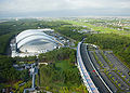 Miyazaki Sea Gaia and Ocean Dome
 -
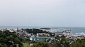 Aoshima and resort area
 -
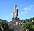 Peace tower with the motto "Hakkō ichiu"


Notable people from Miyazaki[edit]
- Yui Asaka (singer and actress)
- Sky Brown (skateboarder) [17]
- Shinzo Koroki (soccer player)
- Kosei Inoue (judoka)
- Ryunosuke Haga (judoka)
- Kawaguchi Yurina (singer, former member of X21)
References[edit]
- ^ "Miyazaki City official statistics" (in Japanese). Japan.
- ^ 気象庁 / 平年値(年・月ごとの値). Japan Meteorological Agency. Retrieved May 19, 2021.
- ^ 気象庁 / 平年値(年・月ごとの値). JMA. Retrieved May 17, 2022.
- ^ 観測史上1~10位の値(年間を通じての値). JMA. Retrieved May 17, 2022.
- ^ a b Miyazaki population statistics
- ^ Schellinger, Paul; Salkin, Robert, eds. (1996). International Dictionary of Historic Places, Volume 5: Asia and Oceania. Chicago: Fitzroy Dearborn Publishers. pp. 592–594. ISBN 1-884964-04-4.
- ^ "Miyazaki City Official Website". Archived from the original on 2014-10-15. Retrieved 2014-11-05.
- ^ "市町村合併情報 宮崎県 <国土地理協会>". Archived from the original on 2007-06-29. Retrieved 2008-09-13.
- ^ "Sister cities on Miyazaki City Official Website". Archived from the original on 2014-11-05. Retrieved 2015-01-28.
- ^ Travelogue of Hakko Ichiu at 31°56′54″N 131°24′52″E / 31.9483°N 131.41457°E
- ^ http://www.miyazaki-city-zoo.jp/univ/en/ Miyazaki-city
- ^ "Hiking in Beautiful Kaeda Valley - Miyazaki".
- ^ http://miyazaki-spokyo.jp
- ^ "32nd Aoshima Taiheiyo Marathon 2018 | SPORTS ENTRY -Find and register for sports events in Japan-".
- ^ "Miyazaki Mango Products | Authentic Japanese product". Archived from the original on 2021-12-28. Retrieved 2021-12-28.
- ^ "Florante Miyazaki : MIYAZAKI CITY TOURISM ASSOCIATION [JAPAN]". www.miyazaki-city.tourism.or.jp. Archived from the original on 2013-11-23.
- ^ "About Sky Brown, Inc". Penguin Random House. Retrieved 27 August 2020.
External links[edit]
- Official website
 (in Japanese)
  Geographic data related to Miyazaki (city) at OpenStreetMap
| Core city | |
|---|---|
| Cities | |
| Districts | |
| International | |
|---|---|
| National | |
| Geographic | |
| Academics | |