
Kōchi, Kōchi: Difference between revisions
Tags: Mobile edit Mobile app edit Android app edit |
|||
| (23 intermediate revisions by 16 users not shown) | |||
| Line 1: | Line 1: | ||
| ⚫ | |||
{{Short description|City in Japan}} |
{{Short description|City in Japan}} |
||
{{For|the city in India|Kochi}} |
{{For|the city in India|Kochi}} |
||
| ⚫ | |||
{{Use British English|date=September 2022}} |
{{Use British English|date=September 2022}} |
||
{{Infobox settlement |
{{Infobox settlement |
||
| Line 18: | Line 18: | ||
| seal_type = Chapter |
| seal_type = Chapter |
||
<!-- maps and coordinates --> |
<!-- maps and coordinates --> |
||
| image_map = {{maplink|frame=yes|plain=yes|frame-width=265|type=shape|stroke-width=2|stroke-color=#000000|zoom=8}} |
| image_map = {{maplink|frame=yes|frame-align=center|plain=yes|frame-width=265|type=shape|stroke-width=2|stroke-color=#000000|zoom=8}} |
||
| map_alt = |
| map_alt = |
||
| map_caption = Location of Kōchi in Kōchi Prefecture |
| map_caption = Location of Kōchi in Kōchi Prefecture |
||
| Line 35: | Line 35: | ||
| subdivision_name1 = [[Shikoku]] |
| subdivision_name1 = [[Shikoku]] |
||
| subdivision_type2 = [[Prefectures of Japan|Prefecture]] |
| subdivision_type2 = [[Prefectures of Japan|Prefecture]] |
||
| subdivision_name2 = [[Kōchi Prefecture| |
| subdivision_name2 = [[Kōchi Prefecture|Kōchi]] |
||
| subdivision_type3 = [[Districts of Japan|District]] |
| subdivision_type3 = [[Districts of Japan|District]] |
||
| subdivision_name3 = |
| subdivision_name3 = |
||
| Line 55: | Line 55: | ||
| leader_party = |
| leader_party = |
||
| leader_title = Mayor |
| leader_title = Mayor |
||
| leader_name = |
| leader_name = Ryugo Kuwana |
||
| leader_title1 = Vice Mayor |
| leader_title1 = Vice Mayor |
||
| leader_name1 = |
| leader_name1 = |
||
| Line 75: | Line 75: | ||
<!-- population --> |
<!-- population --> |
||
| population_footnotes = <!-- for references: use <ref> tags --> |
| population_footnotes = <!-- for references: use <ref> tags --> |
||
| population_total = |
| population_total = 318,520 |
||
| population_as_of = |
| population_as_of = April 1, 2023 |
||
| population_density_km2 = auto |
| population_density_km2 = auto |
||
| population_est = |
| population_est = |
||
| Line 92: | Line 92: | ||
| blank_info_sec1 = 5-1-45 Honmachi, Kōchi-shi 780-0571 |
| blank_info_sec1 = 5-1-45 Honmachi, Kōchi-shi 780-0571 |
||
<!-- website, footnotes --> |
<!-- website, footnotes --> |
||
| website = {{Official|1=http://www.city.kochi.kochi.jp/}} |
| website = {{Official website|1=http://www.city.kochi.kochi.jp/}} |
||
| footnotes = |
| footnotes = |
||
| module = {{Infobox place symbols| embedded=yes |
| module = {{Infobox place symbols| embedded=yes |
||
| Line 109: | Line 109: | ||
|kanji=高知市 |
|kanji=高知市 |
||
|hiragana=こうちし |
|hiragana=こうちし |
||
|katakana=コウチシ |
|||
|romaji=Kōchi-shi |
|romaji=Kōchi-shi |
||
}} |
}} |
||
{{nihongo|'''Kōchi'''|高知市|Kōchi-shi|extra={{IPA-ja| |
{{nihongo|'''Kōchi'''|高知市|Kōchi-shi|extra={{IPA-ja|koːtɕi ꜜɕi|pron}}}} is the capital [[Cities of Japan|city]] of [[Kōchi Prefecture]] located on the island of [[Shikoku]] in Japan. With over 40% of the prefectural population, Kōchi is the main commercial and industrial centre and the "[[primate city]]" of the prefecture. {{As of|2023|04|01}}, the city had an estimated population of 318,520 in 154,048 households, and a population density of 1,000 persons per km<sup>2</sup>.<ref name="Kōchi-hp">{{cite web |url=https://www.city.kochi.kochi.jp/index2.html|title= Kōchi city official statistics|location= Japan|language= ja}}</ref> The total area of the city is {{convert|309.00|sqkm|sqmi}}. |
||
==Overview== |
==Overview== |
||
A symbol of the city is its most famous dish, [[Skipjack tuna|katsuo]] ''[[tataki]]'', made by lightly [[searing]] and seasoning bonito.<ref>[http://www.city.kochi.kochi.jp/info/english/vis-001-04.htm |
A symbol of the city is its most famous dish, [[Skipjack tuna|katsuo]] ''[[tataki]]'', made by lightly [[searing]] and seasoning bonito.<ref>[http://www.city.kochi.kochi.jp/info/english/vis-001-04.htm] {{webarchive|url=https://web.archive.org/web/20081103130658/http://www.city.kochi.kochi.jp/info/english/vis-001-04.htm|date=November 3, 2008}}</ref> |
||
===Cityscape=== |
===Cityscape=== |
||
<gallery> |
|||
<gallery mode="packed" style="text-align: center;" caption="Gallery" heights="130px" perrow="3"> |
|||
File:Kochi Japan.jpg|[[Skyline]] of Kōchi City(2006) |
File:Kochi Japan.jpg|[[Skyline]] of Kōchi City(2006) |
||
File:080229 Obiyamachi Street Kochi Kochi pref Japan01s.jpg|Obiyamachi in Downtown Kōchi City(2008) |
File:080229 Obiyamachi Street Kochi Kochi pref Japan01s.jpg|Obiyamachi in Downtown Kōchi City(2008) |
||
| Line 139: | Line 138: | ||
* [[Nankoku, Kōchi|Nankoku]] |
* [[Nankoku, Kōchi|Nankoku]] |
||
* [[Tosa, Kōchi|Tosa City]] |
* [[Tosa, Kōchi|Tosa City]] |
||
* [[Tosa, Kōchi (town) |
* [[Tosa, Kōchi (town)|Tosa Town]] |
||
* [[Ino, Kōchi|Ino]] |
* [[Ino, Kōchi|Ino]] |
||
| Line 145: | Line 144: | ||
Kōchi has a very wet [[humid subtropical climate]] ([[Köppen climate classification]] ''Cfa''), receiving twice as much rainfall as Shikoku's other chief cities [[Matsuyama]] and [[Takamatsu, Kagawa|Takamatsu]]. It is also the most [[typhoon]]-prone of Japan's major cities owing to its location directly exposed to the open Pacific Ocean from which the storms enter the country, and has twice received over {{convert|50|cm|abbr=on}} of rainfall in a day from a typhoon. |
Kōchi has a very wet [[humid subtropical climate]] ([[Köppen climate classification]] ''Cfa''), receiving twice as much rainfall as Shikoku's other chief cities [[Matsuyama]] and [[Takamatsu, Kagawa|Takamatsu]]. It is also the most [[typhoon]]-prone of Japan's major cities owing to its location directly exposed to the open Pacific Ocean from which the storms enter the country, and has twice received over {{convert|50|cm|abbr=on}} of rainfall in a day from a typhoon. |
||
{{Weather box|width=auto |
{{Weather box |
||
|width=auto |
|||
|collapsed = Y |
|||
| ⚫ | |||
|single line = Y |
|single line = Y |
||
|metric first = Y |
|metric first = Y |
||
| ⚫ | |||
|Jan record high C = 23.5 |
|Jan record high C = 23.5 |
||
|Feb record high C = 25.2 |
|Feb record high C = 25.2 |
||
| Line 157: | Line 158: | ||
|Jul record high C = 38.3 |
|Jul record high C = 38.3 |
||
|Aug record high C = 38.4 |
|Aug record high C = 38.4 |
||
|Sep record high C = |
|Sep record high C = 37.3 |
||
|Oct record high C = 32.2 |
|Oct record high C = 32.2 |
||
|Nov record high C = 28.0 |
|Nov record high C = 28.0 |
||
| Line 286: | Line 287: | ||
}} |
}} |
||
==Demographics== |
|||
Per Japanese census data,<ref>[https://www.citypopulation.de/php/japan-kochi.php Kōchi population statistics]</ref> the population of Kōchi increased rapidly in the 1960s and 1970s |
Per Japanese census data,<ref>[https://www.citypopulation.de/php/japan-kochi.php Kōchi population statistics]</ref> the population of Kōchi increased rapidly in the 1960s and 1970s before peaking around the year 2000 and going into decline. |
||
{{Historical populations |
{{Historical populations |
||
| 1920 | |
| 1920 | 133,277 |
||
| 1930 | |
| 1930 | 159,010 |
||
| 1940 | |
| 1940 | 163,182 |
||
| 1950 | |
| 1950 | 190,452 |
||
| 1960 | |
| 1960 | 221,737 |
||
| 1970 | |
| 1970 | 265,571 |
||
| 1980 | |
| 1980 | 318,266 |
||
| 1990 | |
| 1990 | 335,287 |
||
| 2000 | |
| 2000 | 348,979 |
||
| 2010 | |
| 2010 | 343,393 |
||
| 2020 | 326,545 |
|||
|align = none |
|align = none |
||
| footnote = |
| footnote = |
||
| Line 337: | Line 339: | ||
[[File:Kochi city hall01 20200918 JST1749.jpg|thumb|200px|Kōchi city hall]] |
[[File:Kochi city hall01 20200918 JST1749.jpg|thumb|200px|Kōchi city hall]] |
||
Kōchi has a [[mayor-council]] form of government with a directly elected mayor and a [[unicameral]] city council of 42 members. |
Kōchi has a [[mayor-council]] form of government with a directly elected mayor and a [[unicameral]] city council of 42 members. |
||
The current mayor (since |
The current mayor (since 2023) is Ryugo Kuwana.<ref>{{Cite web|title=ようこそ!市長室へ|language=ja|trans-title=welcome! To the Mayor's Office|website=Kōchi City |url=https://www.city.kochi.kochi.jp/soshiki/174/info-gaiyou-msg.html|access-date=June 29, 2022}}</ref> |
||
{{ |
{{Clear}} |
||
Kōchi contributes 15 members to the Kōchi Prefectural Assembly. In terms of national politics, the city is divided between the Kōchi 1st district and Kōchi 2nd districts of the [[House of Representatives of Japan|lower house]] of the [[Diet of Japan]]. |
Kōchi contributes 15 members to the Kōchi Prefectural Assembly. In terms of national politics, the city is divided between the Kōchi 1st district and Kōchi 2nd districts of the [[House of Representatives of Japan|lower house]] of the [[Diet of Japan]]. |
||
| Line 373: | Line 375: | ||
|November 9, 2012 |
|November 9, 2012 |
||
|} |
|} |
||
;Sister ports |
|||
{|class="wikitable" |
|||
!City!!Country!![[State (polity)|State]]!!since |
|||
|- |
|||
|[[Subic Bay]] |
|||
|{{Flagicon|PHI}}[[Philippines]] |
|||
|[[Zambales]] |
|||
|February 17, 1998 |
|||
|- |
|||
|[[Qingdao Port|Port of Qingdao]] |
|||
|{{Flagicon|CHN}}China |
|||
|[[Shandong]] |
|||
|April 4, 1998 |
|||
|- |
|||
|[[Port of Colombo]] |
|||
|{{Flagicon|SRI}}[[Sri Lanka]] |
|||
|[[Colombo District]] |
|||
|April 4, 1998 |
|||
|- |
|||
|[[Port of Tanjung Perak]] |
|||
|{{Flagicon|IDN}}Indonesia |
|||
|[[Surabaya]] |
|||
|May 12, 1998 |
|||
|} |
|||
====National==== |
====National==== |
||
;Sister city |
;Sister city |
||
| Line 387: | Line 414: | ||
[[File:Kochi University 20120520.jpg|thumb|200px|[[Kōchi University]]]] |
[[File:Kochi University 20120520.jpg|thumb|200px|[[Kōchi University]]]] |
||
[[File:University of Kochi, Eikokuji Campus.jpg|thumb|200px|[[University of Kochi|Kōchi Prefectural University]]]] |
[[File:University of Kochi, Eikokuji Campus.jpg|thumb|200px|[[University of Kochi|Kōchi Prefectural University]]]] |
||
===Universities=== |
===Universities=== |
||
Kōchi is home to two universities, [[Kōchi University]] (national) and [[University of Kochi]] (prefectural), and four [[junior college]]s including [[Kochi Junior College]]. |
Kōchi is home to two universities, [[Kōchi University]] (national) and [[University of Kochi]] (prefectural), and four [[junior college]]s including [[Kochi Junior College]]. |
||
| Line 396: | Line 424: | ||
*Kochi gakuen university |
*Kochi gakuen university |
||
*[[The Open University of Japan]] |
*[[The Open University of Japan]] |
||
*University of Kochi Health Sciences |
|||
===Schools=== |
===Schools=== |
||
| Line 416: | Line 445: | ||
====Conventional lines==== |
====Conventional lines==== |
||
[[File:JR logo (shikoku).svg|20px]] [[Shikoku Railway Company]] [[JR Shikoku]] {{Color|#e25885|■}}[[Dosan Line]] |
[[File:JR logo (shikoku).svg|20px]] [[Shikoku Railway Company]] [[JR Shikoku]] {{Color|#e25885|■}}[[Dosan Line]] |
||
* {{STN|Tosa-Ōtsu}}{{•}}{{STN|Nunoshida}}{{•}}{{STN|Tosa-Ikku}}{{•}}{{STN|Azōno}}{{•}}'''{{STN|Kōchi|Kōchi}}'''{{•}}{{STN|Iriake}}{{•}}{{STN|Engyōjiguchi}}{{•}}{{STN|Asahi|Kōchi}}{{•}}{{STN|Kōchi-Shōgyō-Mae}}{{•}}{{STN|Asakura|JR Shikoku}} |
* {{STN|Tosa-Ōtsu}}{{•}}{{STN|Nunoshida}}{{•}}{{STN|Tosa-Ikku}}{{•}}{{STN|Azōno}}{{•}}'''{{STN|Kōchi|Kōchi}}'''{{•}}{{STN|Iriake}}{{•}}{{STN|Engyōjiguchi}}{{•}}{{STN|Asahi|Kōchi}}{{•}}{{STN|Kōchi-Shōgyō-Mae}}{{•}}{{STN|Asakura|JR Shikoku}} |
||
===Tramways=== |
===Tramways=== |
||
| Line 430: | Line 459: | ||
===Highways=== |
===Highways=== |
||
Kōchi is also serviced by the Kōchi [[Interchange (road)|interchange]] of the [[Kōchi Expressway]] which connects to the [[Expressways of Japan|national expressway system]]. |
Kōchi is also serviced by the Kōchi [[Interchange (road)|interchange]] of the [[Kōchi Expressway]] which connects to the [[Expressways of Japan|national expressway system]]. |
||
====Expressway==== |
====Expressway==== |
||
*[[File: |
*[[File:JP Expressway E32.svg|30px|link=|alt=]] [[Kōchi Expressway]] |
||
*[[File: |
*[[File:JP Expressway E55.svg|30px|link=|alt=]] [[Kōchi-Tōbu Expressway]] |
||
====Japan National Route==== |
====Japan National Route==== |
||
*{{jct|country=JPN|Route|32}} |
*{{jct|country=JPN|Route|32}} |
||
| Line 443: | Line 474: | ||
===Seaways=== |
===Seaways=== |
||
*Port of Kōchi |
*Port of Kōchi |
||
{{ |
{{Clear}} |
||
==Tourism== |
==Tourism== |
||
| Line 451: | Line 482: | ||
===Local attractions=== |
===Local attractions=== |
||
The mountain {{nihongo|Godaisan|五台山}} holds a public park with views of the city, and is home to stop 31 on the [[Shikoku Pilgrimage]], [[Chikurin-ji (Kōchi)|Chikurin-ji]], as well as the [[Makino Botanical Garden]]. |
The mountain {{nihongo|Godaisan|五台山}} holds a public park with views of the city, and is home to stop 31 on the [[Shikoku Pilgrimage]], [[Chikurin-ji (Kōchi)|Chikurin-ji]], as well as the [[Makino Botanical Garden]]. |
||
Off Museum Road (Kenritsu Bijutsukandori) is [[The Museum of Art, Kōchi]], where the main collection is composed of expressionistic works related to Kōchi.<ref>[http://kochi-bunkazaidan.or.jp/~museum/english_page/welcome.htm |
Off Museum Road (Kenritsu Bijutsukandori) is [[The Museum of Art, Kōchi]], where the main collection is composed of expressionistic works related to Kōchi.<ref>[http://kochi-bunkazaidan.or.jp/~museum/english_page/welcome.htm] {{webarchive|url=https://web.archive.org/web/20080125210204/http://kochi-bunkazaidan.or.jp/~museum/english_page/welcome.htm|date=January 25, 2008}}</ref> |
||
The [[Former Yamauchi Residence]] and [[Tosa Yamauchi Family Treasury and Archives]] are also to be found in the city. |
The [[Former Yamauchi Residence]] and [[Tosa Yamauchi Family Treasury and Archives]] are also to be found in the city. |
||
| Line 470: | Line 501: | ||
The [[Shinto Shrine]] ''[[Tosa jinja]]'' is located to the west.<ref>Kōchi Prefectural Museum of History, [http://www.kochi-bunkazaidan.or.jp/~rekimin/pdf/english.pdf map]; retrieved August 9, 2011</ref> |
The [[Shinto Shrine]] ''[[Tosa jinja]]'' is located to the west.<ref>Kōchi Prefectural Museum of History, [http://www.kochi-bunkazaidan.or.jp/~rekimin/pdf/english.pdf map]; retrieved August 9, 2011</ref> |
||
;Temples |
;Temples |
||
Temples No.30 ([[Zenrakuji]], No.31([[Chikurin-ji (Kōchi)|Chikurin-ji]]) and No.33 ([[Sekkei-ji]]) on the [[Shikoku Pilgrimage]] are located in the city. |
Temples No.30 ([[Zenrakuji]], No.31([[Chikurin-ji (Kōchi)|Chikurin-ji]]) and No.33 ([[Sekkei-ji]]) on the [[Shikoku Pilgrimage]] are located in the city. |
||
At the mouth of Urado Bay, the remnants of Urado Castle (an earlier provincial seat) stand above {{nihongo|Katsurahama|桂浜}}, a famous beach with an aquarium and statue of the Kōchi hero [[#Notable natives and residents|Sakamoto Ryōma]]. |
At the mouth of Urado Bay, the remnants of Urado Castle (an earlier provincial seat) stand above {{nihongo|Katsurahama|桂浜}}, a famous beach with an aquarium and statue of the Kōchi hero [[#Notable natives and residents|Sakamoto Ryōma]]. |
||
Nearby on the grounds is the [[Sakamoto Ryōma Memorial Museum]].<ref>{{cite web |url=http://www.kochi-bunkazaidan.or.jp/~ryoma/english1.htm |title=The Sakamoto Ryoma Memorial Museum |publisher=Kochi-bunkazaidan.or.jp |access-date=2013-12-09 |archive-url=https://web.archive.org/web/20140523005834/http://www.kochi-bunkazaidan.or.jp/~ryoma/english1.htm |archive-date=2014-05-23 |url-status=dead }}</ref> |
Nearby on the grounds is the [[Sakamoto Ryōma Memorial Museum]].<ref>{{cite web |url=http://www.kochi-bunkazaidan.or.jp/~ryoma/english1.htm |title=The Sakamoto Ryoma Memorial Museum |publisher=Kochi-bunkazaidan.or.jp |access-date=2013-12-09 |archive-url=https://web.archive.org/web/20140523005834/http://www.kochi-bunkazaidan.or.jp/~ryoma/english1.htm |archive-date=2014-05-23 |url-status=dead }}</ref> |
||
| Line 479: | Line 510: | ||
File:Chikurin-ji Temple - panoramio (1).jpg|[[Chikurin-ji (Kōchi)|Chikurin-ji]] |
File:Chikurin-ji Temple - panoramio (1).jpg|[[Chikurin-ji (Kōchi)|Chikurin-ji]] |
||
</gallery> |
</gallery> |
||
{{ |
{{Clear}} |
||
==Culture== |
==Culture== |
||
| Line 523: | Line 554: | ||
| style="background:red;"| [[Kochi United SC|<span style="color:lightgreen">Kochi United SC</span>]] |
| style="background:red;"| [[Kochi United SC|<span style="color:lightgreen">Kochi United SC</span>]] |
||
| Soccer |
| Soccer |
||
| [[Japan Football |
| [[Japan Football League]] |
||
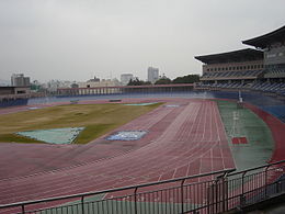
| [[Kochi Haruno Athletic Stadium]] |
| [[Kochi Haruno Athletic Stadium]] |
||
| |
| 2016 |
||
|} |
|} |
||
<gallery mode="packed" style="text-align: center;" caption="" heights="130px" perrow="3"> |
<gallery mode="packed" style="text-align: center;" caption="" heights="130px" perrow="3"> |
||
| Line 534: | Line 565: | ||
File:Kochi Prefectural Gymnasium01ss3200.jpg|Kochi Prefectural Gymnasium |
File:Kochi Prefectural Gymnasium01ss3200.jpg|Kochi Prefectural Gymnasium |
||
</gallery> |
</gallery> |
||
{{ |
{{Clear}} |
||
==Notable people from Kōchi== |
==Notable people from Kōchi== |
||
| Line 552: | Line 583: | ||
*[[Kusunose Kita]] (1836–1920) was an advocate for Women's rights in Japan, particularly in Kochi. |
*[[Kusunose Kita]] (1836–1920) was an advocate for Women's rights in Japan, particularly in Kochi. |
||
*[[Tetsuya Nomura]] (born 1970) is a video game artist, designer and director who currently works for Square Enix. Famous for being a character designer for the Final Fantasy Series. |
*[[Tetsuya Nomura]] (born 1970) is a video game artist, designer and director who currently works for Square Enix. Famous for being a character designer for the Final Fantasy Series. |
||
*Nakamura Kazuha (born 2003) is a member of Korean girl group [[Le Sserafim]]. |
*[[Nakamura Kazuha]] (born 2003) is a member of Korean girl group [[Le Sserafim]]. |
||
*Nonaka Shana (born 2003) is a member of Korean girl group [[Lapillus (group)|Lapillus]]. |
*Nonaka Shana (born 2003) is a member of Korean girl group [[Lapillus (group)|Lapillus]]. |
||
*[[Hideshi Matsuda]] (born 1954) is a racing driver and TV reporter |
|||
{{-}} |
|||
*[[Fumio Nutahara]] (born 1963) is a rally driver |
|||
==References== |
==References== |
||
| Line 565: | Line 597: | ||
*[http://www.city.kochi.kochi.jp/life/5/ Kōchi City official website] {{in lang|en}} |
*[http://www.city.kochi.kochi.jp/life/5/ Kōchi City official website] {{in lang|en}} |
||
* [https://web.archive.org/web/20110427210526/http://attaka.or.jp/foreign/english/index.html Kōchi Visitors and Convention Association official website] |
* [https://web.archive.org/web/20110427210526/http://attaka.or.jp/foreign/english/index.html Kōchi Visitors and Convention Association official website] |
||
* [http://cgi2.nhk.or.jp/michi/cgi/detail.cgi?dasID=D0004200005_00000 Yosakoi Festival in Kōchi City][[NHK]] |
* [http://cgi2.nhk.or.jp/michi/cgi/detail.cgi?dasID=D0004200005_00000 Yosakoi Festival in Kōchi City] {{Webarchive|url=https://web.archive.org/web/20150526085810/http://cgi2.nhk.or.jp/michi/cgi/detail.cgi?dasID=D0004200005_00000 |date=May 26, 2015 }}[[NHK]] |
||
* {{OSM relation|4028510|Kōchi}} |
* {{OSM relation|4028510|Kōchi}} |
||
{{Kōchi Prefecture}} |
{{Kōchi Prefecture}} |
||
| Line 577: | Line 609: | ||
[[Category:Port settlements in Japan]] |
[[Category:Port settlements in Japan]] |
||
[[Category:Populated coastal places in Japan]] |
[[Category:Populated coastal places in Japan]] |
||
[[Category:Kōchi| ]] |
[[Category:Kōchi, Kōchi| ]] |
||
Revision as of 21:03, 12 April 2024
Kōchi
高知市 | |
|---|---|
| Kōchi City | |
 From top left: Katsurahama, Statue of Sakamoto Ryoma, View of Kōchi from Mt. Godai, Yosakoi Festival, Harimayabashi, Tosa Electric Railway, Kōchi Castle | |
 Flag  Chapter | |
 Location of Kōchi in Kōchi Prefecture | |
 | |
 Kōchi Location in Japan | |
| Coordinates: 33°33′32″N 133°31′53″E / 33.55889°N 133.53139°E | |
| Country | Japan |
| Region | Shikoku |
| Prefecture | Kōchi |
| Government | |
| • Mayor | Ryugo Kuwana |
| Area | |
| • Total | 309.00 km2 (119.31 sq mi) |
| Population (April 1, 2023) | |
| • Total | 318,520 |
| • Density | 1,000/km2 (2,700/sq mi) |
| Time zone | UTC+09:00 (JST) |
| City hall address | 5-1-45 Honmachi, Kōchi-shi 780-0571 |
| Website | Official website |
| Symbols | |
| Bird | Japanese wagtail[1] |
| Flower | Winter-hazel[1] |
| Tree | Chinaberry[1] |
| Kōchi | |||||
|---|---|---|---|---|---|
| Japanese name | |||||
| Kanji | 高知市 | ||||
| Hiragana | こうちし | ||||
| |||||
Kōchi (高知市, Kōchi-shi, pronounced [koːtɕi ꜜɕi]) is the capital city of Kōchi Prefecture located on the island of Shikoku in Japan. With over 40% of the prefectural population, Kōchi is the main commercial and industrial centre and the "primate city" of the prefecture. As of 1 April 2023[update], the city had an estimated population of 318,520 in 154,048 households, and a population density of 1,000 persons per km2.[2] The total area of the city is 309.00 square kilometres (119.31 sq mi).
Overview
A symbol of the city is its most famous dish, katsuo tataki, made by lightly searing and seasoning bonito.[3]
Cityscape
-
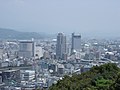 Skyline of Kōchi City(2006)
 -
 Obiyamachi in Downtown Kōchi City(2008)
 -
 Sunday street markets(2009)
 -
 CBD of Kōchi City(2010)
 -
 Views from Kōchi Castle Keep Tower(2013)
 -
 Kōchi Castle(2020)


Geography
.jpg)
Kōchi is located on the southern coast of Kōchi Prefecture, facing the Pacific Ocean to the south. The city area can be divided into three distinct geographic sections. The urban centre lies at the head of Urado Bay, in a narrow alluvial plain crossed by several rivers, notably the Kagami River and Kokubu River. The plain is bounded by mountains to the north and a range of hills to the south and west.
The northern mountains form the least densely populated part of the city, with the only settlement being along narrow river valleys. The highest point in Kōchi is Kuishi-yama at 1,176 metres (3,858 ft).
To the south of the city centre, Urado Bay cuts through the hills to its outlet into the Pacific Ocean. The land surrounding the bay and a small strip of the coastline form the third part of the city. This area, although hillier and less dense than the plain, is nevertheless a major location of housing and port-related industry.
Neighbouring municipalities
Kōchi Prefecture
Climate
Kōchi has a very wet humid subtropical climate (Köppen climate classification Cfa), receiving twice as much rainfall as Shikoku's other chief cities Matsuyama and Takamatsu. It is also the most typhoon-prone of Japan's major cities owing to its location directly exposed to the open Pacific Ocean from which the storms enter the country, and has twice received over 50 cm (20 in) of rainfall in a day from a typhoon.
| Climate data for Kochi (1991–2020 normals, extremes 1886–present) | |||||||||||||
|---|---|---|---|---|---|---|---|---|---|---|---|---|---|
| Month | Jan | Feb | Mar | Apr | May | Jun | Jul | Aug | Sep | Oct | Nov | Dec | Year |
| Record high °C (°F) | 23.5 (74.3) |
25.2 (77.4) |
26.3 (79.3) |
30.0 (86.0) |
32.3 (90.1) |
34.7 (94.5) |
38.3 (100.9) |
38.4 (101.1) |
37.3 (99.1) |
32.2 (90.0) |
28.0 (82.4) |
23.5 (74.3) |
38.4 (101.1) |
| Mean daily maximum °C (°F) | 12.2 (54.0) |
13.2 (55.8) |
16.3 (61.3) |
20.9 (69.6) |
24.8 (76.6) |
27.1 (80.8) |
30.8 (87.4) |
32.1 (89.8) |
29.5 (85.1) |
25.0 (77.0) |
19.6 (67.3) |
14.4 (57.9) |
22.2 (72.0) |
| Daily mean °C (°F) | 6.7 (44.1) |
7.8 (46.0) |
11.2 (52.2) |
15.8 (60.4) |
20.0 (68.0) |
23.1 (73.6) |
27.0 (80.6) |
27.9 (82.2) |
25.0 (77.0) |
19.9 (67.8) |
14.2 (57.6) |
8.8 (47.8) |
17.3 (63.1) |
| Mean daily minimum °C (°F) | 2.1 (35.8) |
3.1 (37.6) |
6.4 (43.5) |
10.9 (51.6) |
15.5 (59.9) |
19.7 (67.5) |
23.9 (75.0) |
24.5 (76.1) |
21.4 (70.5) |
15.6 (60.1) |
9.7 (49.5) |
4.2 (39.6) |
13.1 (55.6) |
| Record low °C (°F) | −7.6 (18.3) |
−7.9 (17.8) |
−6.5 (20.3) |
−0.9 (30.4) |
3.8 (38.8) |
9.1 (48.4) |
14.6 (58.3) |
15.9 (60.6) |
10.0 (50.0) |
2.5 (36.5) |
−1.9 (28.6) |
−6.6 (20.1) |
−7.9 (17.8) |
| Average precipitation mm (inches) | 59.1 (2.33) |
107.8 (4.24) |
174.8 (6.88) |
225.3 (8.87) |
280.4 (11.04) |
359.5 (14.15) |
357.3 (14.07) |
284.1 (11.19) |
398.1 (15.67) |
207.5 (8.17) |
129.6 (5.10) |
83.1 (3.27) |
2,666.4 (104.98) |
| Average snowfall cm (inches) | 0 (0) |
0 (0) |
0 (0) |
0 (0) |
0 (0) |
0 (0) |
0 (0) |
0 (0) |
0 (0) |
0 (0) |
0 (0) |
0 (0) |
1 (0.4) |
| Average precipitation days (≥ 0.5 mm) | 6.0 | 7.5 | 10.5 | 10.4 | 11.1 | 15.1 | 13.7 | 12.9 | 13.2 | 9.0 | 7.3 | 6.4 | 123.2 |
| Average relative humidity (%) | 61 | 60 | 62 | 65 | 70 | 78 | 79 | 76 | 74 | 68 | 68 | 64 | 69 |
| Mean monthly sunshine hours | 190.7 | 177.2 | 192.2 | 197.3 | 195.7 | 133.8 | 173.7 | 204.0 | 162.0 | 179.6 | 168.8 | 184.6 | 2,159.7 |
| Source: Japan Meteorological Agency[4] | |||||||||||||
Demographics
Per Japanese census data,[5] the population of Kōchi increased rapidly in the 1960s and 1970s before peaking around the year 2000 and going into decline.
| Year | Pop. | ±% |
|---|---|---|
| 1920 | 133,277 | — |
| 1930 | 159,010 | +19.3% |
| 1940 | 163,182 | +2.6% |
| 1950 | 190,452 | +16.7% |
| 1960 | 221,737 | +16.4% |
| 1970 | 265,571 | +19.8% |
| 1980 | 318,266 | +19.8% |
| 1990 | 335,287 | +5.3% |
| 2000 | 348,979 | +4.1% |
| 2010 | 343,393 | −1.6% |
| 2020 | 326,545 | −4.9% |
History
Feudal period
As with all of Kōchi Prefecture, the area of Nahari was part of ancient Tosa Province. The river plain now containing the city centre was originally settled as a castle town around Kōchi Castle, the seat of the daimyō of Tosa Domain. The castle site was chosen by Yamauchi Kazutoyo in 1601 to replace the earlier seats of the Chōsokabe clan who had previously ruled in province. The city takes its name from that of the castle. As the centre of administration for the province, and the prefecture which succeeded it, the town rapidly grew to become the largest settlement of the region.


Meiji period
During the time of the Meiji Restoration, Kōchi became famous as a centre of pro-imperial ideology, and later for incubating democratic and human rights movements. The city was incorporated on April 1, 1889, with the establishment of the modern municipalities system..
Tram service began in the city on May 2, 1904, and the city was connected to the national rail network on November 12, 1951.


WWII air raid
Kōchi was selected as a target by the United States' XXI Bomber Command because of the city's status as a prefectural capital, and the fact that it was a centre for industry and commercial trade. On July 3, 1945, at 6:22 pm (JST) 129 aircraft took off to bomb Kōchi. 1060 tons of incendiary bombs were dropped on Kōchi, destroying 48% of the built up areas of the city, killing 401 civilians and rendering over 40,000 homeless.[6]
Modern period
On April 1, 1998, the city was designated as the first core city on Shikoku.
On January 1, 2005, the villages of Kagami and Tosayama, both from Tosa District were merged into Kōchi.
On January 1, 2008, the town of Haruno (from Agawa District) was also merged into Kōchi.
Government

Kōchi has a mayor-council form of government with a directly elected mayor and a unicameral city council of 42 members. The current mayor (since 2023) is Ryugo Kuwana.[7]
Kōchi contributes 15 members to the Kōchi Prefectural Assembly. In terms of national politics, the city is divided between the Kōchi 1st district and Kōchi 2nd districts of the lower house of the Diet of Japan.
External relations
Twin towns/sister cities
International
- Sister Cities
| City | Country | State | since |
|---|---|---|---|
| Fresno | California | February 11, 1965 | |
| Surabaya | East Java | April 17, 1997[8] |
- Friendship city
| City | Country | State | since |
|---|---|---|---|
| Wuhu | Anhui | April 19, 1985 | |
| Mokpo | South Jeolla Province | November 9, 2012 |
- Sister ports
| City | Country | State | since |
|---|---|---|---|
| Subic Bay | Zambales | February 17, 1998 | |
| Port of Qingdao | Shandong | April 4, 1998 | |
| Port of Colombo | Colombo District | April 4, 1998 | |
| Port of Tanjung Perak | Surabaya | May 12, 1998 |
National
- Sister city
| City | Prefecture | region | since |
|---|---|---|---|
| Kitami | Hokkaidō region | April 28, 1986 |
Education


Universities
Kōchi is home to two universities, Kōchi University (national) and University of Kochi (prefectural), and four junior colleges including Kochi Junior College.
- National university
- Public university
- Private university
- Kochi gakuen university
- The Open University of Japan
- University of Kochi Health Sciences
Schools
- Elementary and secondary education
Kōchi has 39 public elementary schools, 17 public middle schools and one public high school operated by the city government, one private and one national elementary school, and five private combined middle/high schools. The city has eight public high schools administered by the Kōchi Prefectural Department of Education. The prefecture also operates one middle school and one combined middle/high school.
Transport


Airport
- Kōchi Ryōma Airport, located in nearby Nankoku
Railways
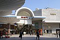
Kōchi is located on the JR Shikoku's Dosan Line connecting it to northern Shikoku, and via interchanges with the Tosa Kuroshio Railway to the eastern and western parts of Kōchi Prefecture. JR's central station in Kōchi is Kōchi Station.
Conventional lines
![]() Shikoku Railway Company JR Shikoku ■Dosan Line
Shikoku Railway Company JR Shikoku ■Dosan Line
- Tosa-Ōtsu • Nunoshida • Tosa-Ikku • Azōno • Kōchi • Iriake • Engyōjiguchi • Asahi • Kōchi-Shōgyō-Mae • Asakura
Tramways
The most visible form of transport within Kōchi is the tram service run by Tosaden Kōtsū. Its three lines with historic cars service the major north–south and east–west axes of the city.
Busways
The city also has an extensive bus network.
Highways
Kōchi is also serviced by the Kōchi interchange of the Kōchi Expressway which connects to the national expressway system.
Expressway
Japan National Route
 National Route 32
 National Route 33
 National Route 55
 National Route 56
 National Route 194
 National Route 195
Seaways
- Port of Kōchi
Tourism

.jpg)
Kōchi Castle still exists in its pre-restoration form, and is one of the main tourist attractions. Other places of interest in the city centre are the Obiyamachi (帯屋町) shopping arcade, the regular Sunday street markets which are close to a kilometre in length, and Harimaya-bashi (はりまや橋), a bridge that featured in a famous Kōchi song about the forbidden love of a Buddhist priest.
Local attractions
The mountain Godaisan (五台山) holds a public park with views of the city, and is home to stop 31 on the Shikoku Pilgrimage, Chikurin-ji, as well as the Makino Botanical Garden.
Off Museum Road (Kenritsu Bijutsukandori) is The Museum of Art, Kōchi, where the main collection is composed of expressionistic works related to Kōchi.[9]
The Former Yamauchi Residence and Tosa Yamauchi Family Treasury and Archives are also to be found in the city.
-
 Katsurahama Aquarium
 -
-

-
 Sawada Mansion


Historic spots
- Castle
- Kōchi Castle
- Urado Castle ruins
- Shrine
The Shinto Shrine Tosa jinja is located to the west.[10]
- Temples
Temples No.30 (Zenrakuji, No.31(Chikurin-ji) and No.33 (Sekkei-ji) on the Shikoku Pilgrimage are located in the city.
At the mouth of Urado Bay, the remnants of Urado Castle (an earlier provincial seat) stand above Katsurahama (桂浜), a famous beach with an aquarium and statue of the Kōchi hero Sakamoto Ryōma.
Nearby on the grounds is the Sakamoto Ryōma Memorial Museum.[11]

.jpg)
Culture


Festival・Events
- Festival
Kōchi's most famous festival is the Yosakoi which is held in August. Teams of dancers dance to traditional and modern songs at various places around Kōchi. The total number of dancers is in the thousands.
- Events
- Sunday street markets
Gourmet
- Katsuo-no-tataki
- Katsuobushi
- SawachiDish Sushi
- Tosa-maki
Museums
- Kōchi Castle Museum of History
- Kōchi Literary Museum
- Ryōma's Birthplace Memorial Museum
- Sakamoto Ryōma Memorial Museum
- The Museum of Art, Kōchi
Sports
| Club | Sport | League | Venue | Established |
|---|---|---|---|---|
| Kōchi Fighting Dogs | Baseball | Shikoku Island League Plus | Kochi Municipal Baseball Park, Kochi Prefectural Haruno Baseball Stadium | 2005 |
| Kochi United SC | Soccer | Japan Football League | Kochi Haruno Athletic Stadium | 2016 |
-
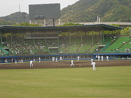 Kōchi Fighting Dogs
(Kochi Prefectural Haruno Baseball Stadium) -

-

-
-
 Kochi Prefectural Gymnasium


Notable people from Kōchi

- Nakahama Manjirō (1827–1898) was one of the first Japanese people to visit the United States and an important translator during the opening of Japan.
- Okada Izō (1832–1865) was a samurai of the late Edo period, feared as one of the four most notable assassins of the Bakumatsu period.
- Sakamoto Ryōma (1836–1867) was a leader of the movement to overthrow the Tokugawa shogunate during the Bakumatsu period.
- Itagaki Taisuke (1837–1919) was a politician and leader of the Freedom and People's Rights Movement, which evolved into Japan's first political party.
- Tsutomu Seki (born 1930) is an astronomer who has discovered a number of comets and asteroids.
- Nobuo Uematsu (born 1959) is a video game composer, best known for scoring the majority of titles in the Final Fantasy series.
- Ryōko Hirosue (born 1980) is an actress and pop star, best known in the West for her roles in the Luc Besson-produced Wasabi and the Academy Award-winning Japanese film Departures.
- Aaron Zagory (born 1985) is a Kōchi-born former US college football player, and the starting kicker for Stanford University in 2006 and 2008.
- Sumi Shimamoto (born 1954) is an anime voice actress, best known for playing Kyoko Otonashi in Maison Ikkoku and Nausicaa in Nausicaa of the Valley of the Wind.
- Noa Tsurushima (born 2001) is a model and actress, best known for portraying Is and As in Kamen Rider Zero-One.
- Tomitaro Makino (1862–1957) was a pioneering botanist, sometimes referred to as the Father of Japanese Botany.
- Kusunose Kita (1836–1920) was an advocate for Women's rights in Japan, particularly in Kochi.
- Tetsuya Nomura (born 1970) is a video game artist, designer and director who currently works for Square Enix. Famous for being a character designer for the Final Fantasy Series.
- Nakamura Kazuha (born 2003) is a member of Korean girl group Le Sserafim.
- Nonaka Shana (born 2003) is a member of Korean girl group Lapillus.
- Hideshi Matsuda (born 1954) is a racing driver and TV reporter
- Fumio Nutahara (born 1963) is a rally driver
References
- ^ a b c [1] Archived October 14, 2008, at the Wayback Machine
- ^ "Kōchi city official statistics" (in Japanese). Japan.
- ^ [2] Archived November 3, 2008, at the Wayback Machine
- ^ 気象庁 / 平年値(年・月ごとの値). Japan Meteorological Agency. Retrieved May 19, 2021.
- ^ Kōchi population statistics
- ^ "21st Bomber Command Tactical Mission Report 247, 250, Ocr". Scribd.com. Retrieved December 9, 2013.
- ^ "ようこそ!市長室へ" [welcome! To the Mayor's Office]. Kōchi City (in Japanese). Retrieved June 29, 2022.
- ^ "The Twin City". Surabaya.go.id. Archived from the original on December 14, 2013. Retrieved December 9, 2013.
- ^ [3] Archived January 25, 2008, at the Wayback Machine
- ^ Kōchi Prefectural Museum of History, map; retrieved August 9, 2011
- ^ "The Sakamoto Ryoma Memorial Museum". Kochi-bunkazaidan.or.jp. Archived from the original on May 23, 2014. Retrieved December 9, 2013.
External links
- Kōchi City official website (in Japanese)
- Kōchi City official website (in English)
- Kōchi Visitors and Convention Association official website
- Yosakoi Festival in Kōchi City Archived May 26, 2015, at the Wayback MachineNHK
 Geographic data related to Kōchi at OpenStreetMap
| Core city | ||
|---|---|---|
| Cities | ||
| Districts | ||
| International | |
|---|---|
| National | |
| Geographic | |
| Academics | |