Nemuro Subprefecture: Difference between revisions
Content deleted Content added
TheInfernoX (talk | contribs) No edit summary |
Undid revision 1170285159 by 182.2.82.73 (talk) do not see why it should be removed |
||
| (33 intermediate revisions by 14 users not shown) | |||
| Line 5: | Line 5: | ||
|official_name = Nemuro-shinkō-kyoku |
|official_name = Nemuro-shinkō-kyoku |
||
|image_map = Nemuro Subprefecture.png |
|image_map = Nemuro Subprefecture.png |
||
|image_skyline = |
|||
|seat = [[Nemuro, Hokkaido|Nemuro]] |
|seat = [[Nemuro, Hokkaido|Nemuro]] |
||
|seat_type = Capital |
|seat_type = Capital |
||
| Line 20: | Line 21: | ||
}} |
}} |
||
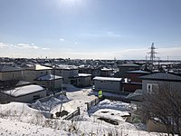
[[File:東根室駅から南西方向を望む.jpg|thumb|200px|[[Nemuro, Hokkaido|Nemuro City]] in Hokkaido.]] |
|||
{{nihongo|'''Nemuro'''|根室振興局|Nemuro-shinkō-kyoku}} is a [[Subprefectures of Hokkaido|subprefecture]] of [[Hokkaido|Hokkaido Prefecture]], [[Japan]]. The Japanese claim the disputed [[Kuril Islands dispute|Southern Kuril Islands]] (known as the Northern Territories in Japan) as part of this subprefecture. |
|||
{{Nihongo|'''Nemuro'''|根室振興局|Nemuro-shinkō-kyoku}} is a [[Subprefectures of Hokkaido|subprefecture]] of [[Hokkaido|Hokkaido Prefecture]], [[Japan]]. Japan claims the southern parts of the [[Kuril Islands dispute|disputed]] |
|||
As of July 31, 2004, the subprefecture has an estimated population of 86,152 and a (claimed) area of 8533.96 km². |
|||
[[Kuril Islands]] (known as the Northern Territories in Japan) as part of this subprefecture. |
|||
[[Nakashibetsu Airport]], the easternmost airport in Japan, is located in the |
As of March 2009, the subprefecture has an estimated population of 84,035, and an area of 3406.23 km². |
||
[[Nakashibetsu Airport]], the easternmost airport in Japan, is located in the town of [[Nakashibetsu, Hokkaido|Nakashibetsu]], [[Shibetsu District, Hokkaido|Shibetsu District]]. |
|||
== History == |
== History == |
||
| Line 30: | Line 34: | ||
*November 1897: Shana Subprefecture established. |
*November 1897: Shana Subprefecture established. |
||
*December 1903: Shana Subprefecture and Nemuro Subprefecture merged. |
*December 1903: Shana Subprefecture and Nemuro Subprefecture merged. |
||
*August 1945: [[Soviet Union|Soviets]] |
*August 1945: [[Soviet Union|Soviets]] occupied the Kuril Islands. |
||
== Geography == |
== Geography == |
||
[[File:Hokkaido-Southern-Kuril-Islands-Japan-Northern-Territories.png|thumb|250px|Satellite photo of Hokkaido and the southern Kuril islands (Northern Territories)]] |
|||
[[Image:Nemuro Subprefecture Map.gif|thumb|300px|Nemuro Subprefecture (under Japanese control)]] |
|||
=== |
===Municipalities=== |
||
{| class="wikitable sortable" |
|||
* [[Nemuro, Hokkaido|Nemuro]] (capital) |
|||
! colspan="2" |Name |
|||
! rowspan="2" |Area (km<sup>2</sup>) |
|||
===Towns and villages by district=== |
|||
! rowspan="2" |Population |
|||
* [[Menashi District, Hokkaido|Menashi District]] |
|||
! rowspan="2" |District |
|||
** [[Rausu, Hokkaido|Rausu]] |
|||
! rowspan="2" |Type |
|||
* [[Notsuke District, Hokkaido|Notsuke District]] |
|||
! rowspan="2" |Map |
|||
** [[Betsukai, Hokkaido|Betsukai]] |
|||
|- |
|||
* [[Shibetsu District, Hokkaido|Shibetsu District]] |
|||
![[Romanization of Japanese|Rōmaji]] |
|||
** [[Nakashibetsu, Hokkaido|Nakashibetsu]] |
|||
![[Kanji]] |
|||
** [[Shibetsu, Hokkaido (Nemuro)|Shibetsu]] |
|||
|- |
|||
|[[File:Flag of Betsukai, Hokkaido.svg|frameless|25x25px]] [[Betsukai, Hokkaido|Betsukai]] |
|||
|別海町 |
|||
|1,320.15 |
|||
|15,179 |
|||
|[[Notsuke District, Hokkaido|Notsuke District]] |
|||
|Town |
|||
|[[File:Betsukai in Hokkaido Prefecture Ja.svg|frameless|50x50px]] |
|||
|- |
|||
|[[File:Flag of Nakashibetsu, Hokkaido.svg|frameless|25x25px]] [[Nakashibetsu, Hokkaido|Nakashibetsu]] |
|||
|中標津町 |
|||
|684.98 |
|||
|24,014 |
|||
|[[Shibetsu District, Hokkaido|Shibetsu District]] |
|||
|Town |
|||
|[[File:Nakashibetsu in Hokkaido Prefecture Ja.svg|frameless|55x55px]] |
|||
|- |
|||
|[[File:Flag of Nemuro, Hokkaido.svg|frameless|25x25px]] [[Nemuro, Hokkaido|Nemuro]] (capital) |
|||
|根室市 |
|||
|512.63 |
|||
|27,109 |
|||
|''no district'' |
|||
|City |
|||
|[[File:Nemuro in Hokkaido Prefecture Ja.svg|frameless|55x55px]] |
|||
|- |
|||
|[[File:Flag of Rausu, Hokkaido.svg|frameless|25x25px]] [[Rausu, Hokkaido|Rausu]] |
|||
|羅臼町 |
|||
|397.88 |
|||
|5,395 |
|||
|[[Menashi District, Hokkaido|Menashi District]] |
|||
|Town |
|||
|[[File:Rausu in Hokkaido Prefecture Ja.svg|frameless|55x55px]] |
|||
|- |
|||
|[[File:Flag of Shibetsu, Nemuro, Hokkaido.svg|frameless|25x25px]] [[Shibetsu, Hokkaido (Nemuro)|Shibetsu]] |
|||
|標津町 |
|||
|624.49 |
|||
|5,374 |
|||
|[[Shibetsu District, Hokkaido|Shibetsu District]] |
|||
|Town |
|||
|[[File:Shibetsu town in Hokkaido Prefecture Ja.svg|frameless|55x55px]] |
|||
|} |
|||
===Districts in the Northern Territories=== |
===Districts in the Northern Territories=== |
||
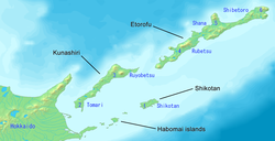
[[File:Kuril-Islands-Northern-Territories-of-Japan-Map.png|thumb|250px|Nemuro Subprefecture is in north eastern Hokkaido. It shows the names of the claimed islands and districts (Northern Territories)]] |
|||
:''Also known as the Southern Kuril Islands (administered by [[Russia]], claimed by Japan), see [[Kuril Islands dispute]].'' |
|||
:Also known as the Southern Kuril Islands (administered by [[Russia]], claimed by Japan; see [[Kuril Islands dispute]]): |
|||
*[[Shikotan District, Hokkaido|Shikotan]] |
|||
{| class="wikitable sortable" |
|||
** [[Shikotan, Hokkaido|Shikotan]] |
|||
! colspan="2" |Name |
|||
*[[Kunishiri District, Hokkaido|Kunashiri]] ([[Kunashir]]) |
|||
! rowspan="2" |Area (km<sup>2</sup>) |
|||
** [[Tomari, Hokkaido|Tomari]] ([[Golovnino]]) |
|||
! rowspan="2" |Population |
|||
** [[Ruyobetsu, Hokkaido|Ruyobetsu]] ([[Yuzhno Kurilsk]]) |
|||
! rowspan="2" |District |
|||
*[[Etorofu District, Hokkaido|Etorofu]] ([[Iturup]]) |
|||
! rowspan="2" |Type |
|||
** [[Rubetsu, Hokkaido|Rubetsu]] ([[Types of inhabited localities in Russia|Pioner]]) |
|||
! rowspan="2" |Map |
|||
*[[Shana District, Hokkaido|Shana]] |
|||
|- |
|||
** [[Shana, Hokkaido|Shana]] ([[Kurilsk]]) |
|||
![[Romanization of Japanese|Rōmaji]] |
|||
*[[Shibetoro District, Hokkaido|Shibetoro]] |
|||
![[Kanji]] |
|||
** [[Shibetoro, Hokkaido|Shibetoro]] ([[Types of inhabited localities in Russia|Rudnaya]]) |
|||
|- |
|||
|[[Rubetsu, Hokkaido|Rubetsu]] ([[Types of inhabited localities in Russia|Pioner]]) |
|||
|留別村 |
|||
|1,442.82 |
|||
|2,814 |
|||
|[[Etorofu District]] ([[Iturup]]) |
|||
|Village |
|||
|[[File:Rubetsu in Nemuro Subprefecture.gif|frameless|50x50px]] |
|||
|- |
|||
|[[Ruyobetsu, Hokkaido|Ruyobetsu]] ([[Yuzhno-Kurilsk]]) |
|||
|留夜別村 |
|||
|960.27 |
|||
|3,401 |
|||
|[[Kunashiri District]] ([[Kunashir Island|Kunashir]]) |
|||
|Village |
|||
|[[File:Ruyobetsu in Nemuro Subprefecture.gif|frameless|50x50px]] |
|||
|- |
|||
|[[Shana, Hokkaido|Shana]] ([[Kurilsk]]) |
|||
|紗那村 |
|||
|973.3 |
|||
|1,426 |
|||
|[[Shana District]] |
|||
|Village |
|||
|[[File:Shyna in Nemuro Subprefecture.gif|frameless|50x50px]] |
|||
|- |
|||
|[[Shibetoro municipality|Shibetoro]] ([[Types of inhabited localities in Russia|Rudnaya]]) |
|||
|蘂取村 |
|||
|760.5 |
|||
|881 |
|||
|[[Shibetoro District, Hokkaido|Shibetoro District]] |
|||
|Village |
|||
|[[File:Shibetoro in Nemuro Subprefecture.gif|frameless|50x50px]] |
|||
|- |
|||
|[[Shikotan, Hokkaido|Shikotan]] |
|||
|色丹村 |
|||
|253.33 |
|||
|1,499 |
|||
|[[Shikotan|Shikotan District]] |
|||
|Village |
|||
|[[File:Shikotan in Nemuro Subprefecture.gif|frameless|50x50px]] |
|||
|- |
|||
|[[Tomari, Hokkaido (Nemuro)|Tomari]] ([[Golovnino]]) |
|||
|泊村 |
|||
|538.56 |
|||
|5,595 |
|||
|[[Kunashiri District]] ([[Kunashir Island|Kunashir]]) |
|||
|Village |
|||
|[[File:Tomari in Nemuro Subprefecture.gif|frameless|50x50px]] |
|||
|} |
|||
===Districts renounced in [[San Francisco Treaty]]=== |
===Districts renounced in [[San Francisco Treaty]]=== |
||
[[Image:Nemuro Subprefecture Map (include Southern Chishima).gif|thumb| |
[[Image:Nemuro Subprefecture Map (include Southern Chishima).gif|thumb|250px|Nemuro Subprefecture is blue. The claimed islands and districts (Northern Territories) are grey.]] |
||
*[[Uruppu District, Hokkaido|Uruppu]] ([[Urup]]) |
*[[Uruppu District, Hokkaido|Uruppu]] ([[Urup]]) |
||
*[[Shimushiru District, Hokkaido|Shimushiru]] ([[Simushir]]) |
*[[Shimushiru District, Hokkaido|Shimushiru]] ([[Simushir]]) |
||
| Line 70: | Line 163: | ||
===Islands=== |
===Islands=== |
||
* [[Habomai]] Rocks |
* [[Habomai]] Rocks |
||
* [[Shikotan]] Island |
* [[Shikotan]] Island |
||
| Line 80: | Line 172: | ||
==External links== |
==External links== |
||
*[http://www.nemuro.pref.hokkaido.jp/ Official Website] {{ |
*[https://web.archive.org/web/20050420021728/http://www.nemuro.pref.hokkaido.jp/ Official Website] {{in lang|ja}} |
||
{{coord|43.33038|145.584389|format=dms|display=title|type:city_region:JP_scale:100000}} |
{{coord|43.33038|145.584389|format=dms|display=title|type:city_region:JP_scale:100000}} |
||
| Line 88: | Line 180: | ||
[[Category:Southern Kuriles]] |
[[Category:Southern Kuriles]] |
||
[[Category:Subprefectures in Hokkaido]] |
[[Category:Subprefectures in Hokkaido]] |
||
{{Hokkaido-geo-stub}} |
|||
Latest revision as of 15:53, 14 August 2023
Nemuro Subprefecture
根室振興局 | |
|---|---|
| Nemuro-shinkō-kyoku | |
 | |
| Prefecture | Hokkaido |
| Capital | Nemuro |
| Area | |
| • Total | 3,406.23 km2 (1,315.15 sq mi) |
| Population (March 2009) | |
| • Total | 84,035 |
| • Density | 25/km2 (64/sq mi) |
| Website | nemuro.pref.hokkaido.lg.jp |

Nemuro (根室振興局, Nemuro-shinkō-kyoku) is a subprefecture of Hokkaido Prefecture, Japan. Japan claims the southern parts of the disputed Kuril Islands (known as the Northern Territories in Japan) as part of this subprefecture.
As of March 2009, the subprefecture has an estimated population of 84,035, and an area of 3406.23 km².
Nakashibetsu Airport, the easternmost airport in Japan, is located in the town of Nakashibetsu, Shibetsu District.
History[edit]
- November 1897: Nemuro Subprefecture established.
- November 1897: Shana Subprefecture established.
- December 1903: Shana Subprefecture and Nemuro Subprefecture merged.
- August 1945: Soviets occupied the Kuril Islands.
Geography[edit]

Municipalities[edit]
| Name | Area (km2) | Population | District | Type | Map | |
|---|---|---|---|---|---|---|
| Rōmaji | Kanji | |||||
| 別海町 | 1,320.15 | 15,179 | Notsuke District | Town | ||
| 中標津町 | 684.98 | 24,014 | Shibetsu District | Town | 
| |
| 根室市 | 512.63 | 27,109 | no district | City | 
| |
| 羅臼町 | 397.88 | 5,395 | Menashi District | Town | 
| |
| 標津町 | 624.49 | 5,374 | Shibetsu District | Town | 
| |
Districts in the Northern Territories[edit]

- Also known as the Southern Kuril Islands (administered by Russia, claimed by Japan; see Kuril Islands dispute):
| Name | Area (km2) | Population | District | Type | Map | |
|---|---|---|---|---|---|---|
| Rōmaji | Kanji | |||||
| Rubetsu (Pioner) | 留別村 | 1,442.82 | 2,814 | Etorofu District (Iturup) | Village | |
| Ruyobetsu (Yuzhno-Kurilsk) | 留夜別村 | 960.27 | 3,401 | Kunashiri District (Kunashir) | Village | |
| Shana (Kurilsk) | 紗那村 | 973.3 | 1,426 | Shana District | Village | |
| Shibetoro (Rudnaya) | 蘂取村 | 760.5 | 881 | Shibetoro District | Village | |
| Shikotan | 色丹村 | 253.33 | 1,499 | Shikotan District | Village | |
| Tomari (Golovnino) | 泊村 | 538.56 | 5,595 | Kunashiri District (Kunashir) | Village | |
Districts renounced in San Francisco Treaty[edit]

Islands[edit]
Mergers[edit]
External links[edit]
- Official Website (in Japanese)
